Mean Circulation Highlights and Climate Anomalies September through December 2010
Anthony Artusa, Meteorologist, Climate Operations Branch, Climate Prediction Center NCEP/NWS/NOAA
September-October 2010
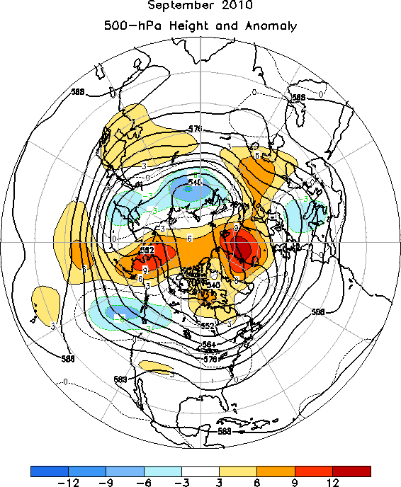
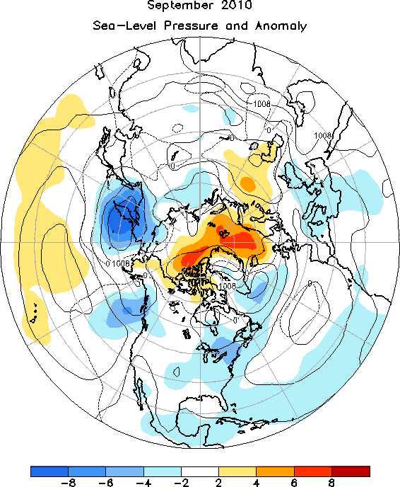
The 500-hPa circulation pattern over the Northern Hemisphere during September featured above-average heights over Greenland, northern Russia, eastern Asia, and Alaska, and below-average heights in the Gulf of Alaska, south-central Europe, and central Siberia Figure 1. The sea-level pressure (SLP) pattern largely mirrored the 500-hPa pattern, and emphasizes the persistent area of lower than normal SLP centered over Kamchatka Figure 2.
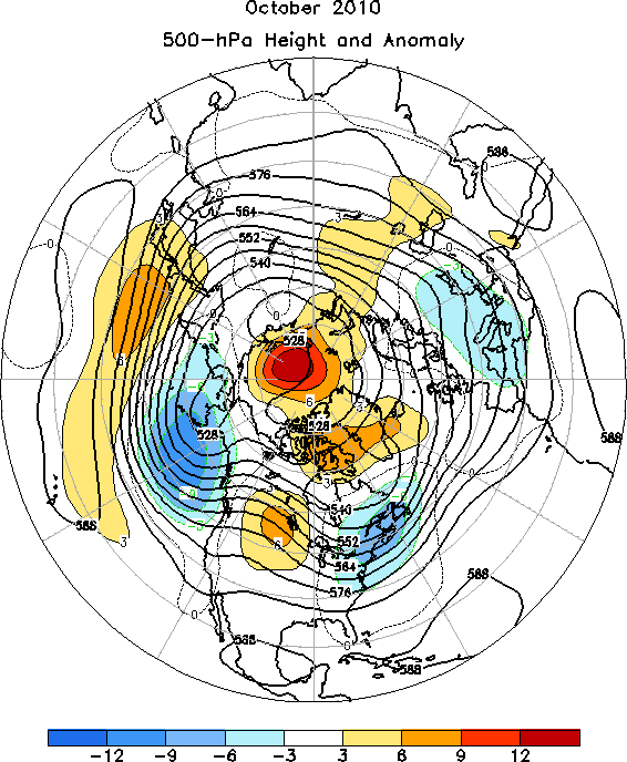
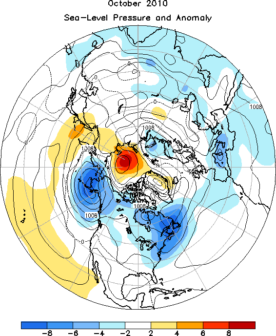
The mid-tropospheric circulation during October 2010 featured above-average heights over western North America, Greenland, and across the western and central North Pacific Ocean, and below-average heights over the Gulf of Alaska, eastern Canada and far northeastern contiguous U.S., and southern Europe Figure 3. The SLP map again largely mirrored the mid-tropospheric pattern, including well below-average SLP centered over the Aleutians and also the southern Canadian Maritimes Figure 4.
Of special significance during October was the so-called North American Extra-tropical Cyclone of October 26-27, 2010 (see Reference 1), which is notable for several reasons. Bigfork, Minnesota reported a minimum observable SLP of 955.2-hPa, which set a new record for Minnesota. Similarly, Superior, Wisconsin set a new minimum SLP record (961.3-hPa) for the state of Wisconsin. In addition to breaking lowest SLP records, this storm brought wind gusts as high as 55-65 kts to the region, 29.2 cm of snow at Duluth, MN (4th greatest storm total snowfall in October), and as much as 12.5 cm of rain. The western mid-lake buoy on Lake Superior reported significant wave heights up to 5.7 meters, with even higher values reported on the Canadian side of the Lake.
The Tropics
Negative sea surface temperature (SST) anomalies continued to strengthen across the equatorial Pacific Ocean during September and October 2010. The latest monthly SST indices for the Nino 3.4 region were -1.6C (for both September and October). The oceanic thermocline, measured by the depth of the 20C isotherm, was shallower than average across the central and eastern equatorial Pacific. Atmospheric convection was enhanced over Indonesia, and suppressed across the western and central equatorial Pacific. Equatorial low-level easterly trade winds and upper-level westerly wind anomalies remained stronger than average over the western and central Pacific. Collectively, the atmospheric and oceanic anomalies signal the ongoing La Nina.
The second half of the 2010 Atlantic hurricane season continued to be unusually active. Despite this, most of the tropical storms and hurricanes remained well offshore, sparing the United States (see References 2,3). The strongest hurricane of the season, Igor, followed the pattern of a classical Cape Verde-type storm. After emerging off the west coast of Africa as an area of disturbed weather, the system moved westward across the low-latitude Atlantic, peaking as a borderline Category 4/5 hurricane with 135 kt winds as it began to gradually recurve northwestward and then northward, sparing the Leeward Islands. Shortly thereafter, it rapidly weakened to a strong Category-1 hurricane as it passed just west of Bermuda, bringing peak wind gusts of at least 80 kts to that area. Bermuda escaped major damage with this hurricane, which would continue northward and transition into an extra-tropical (cold core) cyclone, before causing significant damage 1-2 days later to Newfoundland. In stark contrast to the very active Atlantic hurricane season, the East Pacific hurricane season was one of the most inactive seasons since the satellite era began.
November - December 2010
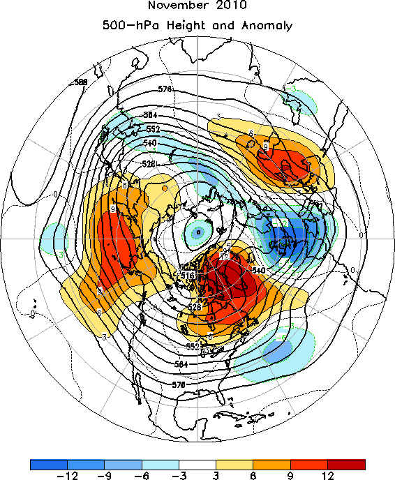
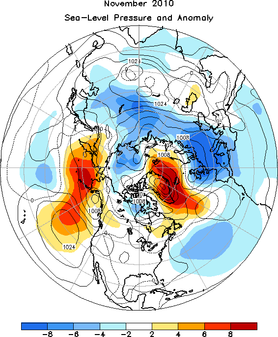
The 500-hPa circulation pattern during November 2010 featured above-average heights over the far northern Pacific, eastern Canada, Greenland, and western Russia, and below-average heights over the central North Atlantic, Europe, and central Siberia Figure 5. The sea-level pressure and anomaly map (Figure 6) records well below-average SLP over much of Europe and Russia.
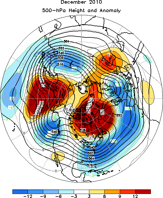
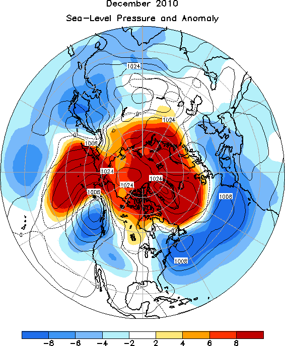
The month of December was characterized by a strong, negative phase of the Arctic Oscillation (AO), with well above-average 500-hPa heights across the polar region, and well below-average 500-hPa heights over middle latitudes of the Northern Hemisphere Figure 7. This pattern also projects strongly (-1.8) onto the negative phase of the North Atlantic Oscillation (NAO). The SLP and anomaly map (Figure 8) reflected the mid-tropospheric pattern quite well.
The Tropics
Negative SST anomalies persisted across the equatorial Pacific Ocean during November and December 2010. The latest monthly SST index for the Nino 3.4 region registered -1.5C for both months. The oceanic thermocline (measured by the depth of the 20C isotherm) remained much shallower than average across the central and eastern equatorial Pacific, with sub-surface temperatures reaching 1C to 5C below average in these regions. Deep cloudiness and thunderstorm activity near the equator was enhanced over Indonesia, and was suppressed over the western and central equatorial Pacific. Equatorial low-level easterly trade winds and upper-level westerly winds remained stronger than average over the western and central Pacific. These atmospheric and oceanic anomalies reflect the ongoing moderate to strong La Nina.
References
Back to top