Mean Circulation Highlights and Climate Anomalies January through April 2016
Anthony Artusa, Meteorologist, Operations Branch,
Climate Prediction Center NCEP/NWS/NOAA
All anomalies reflect departures from the 1981-2010 base period.
January-February 2016
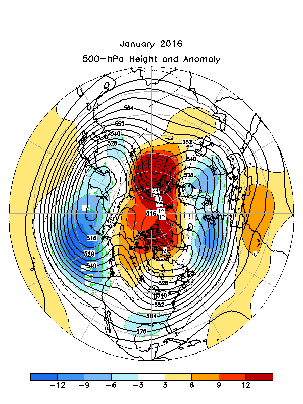
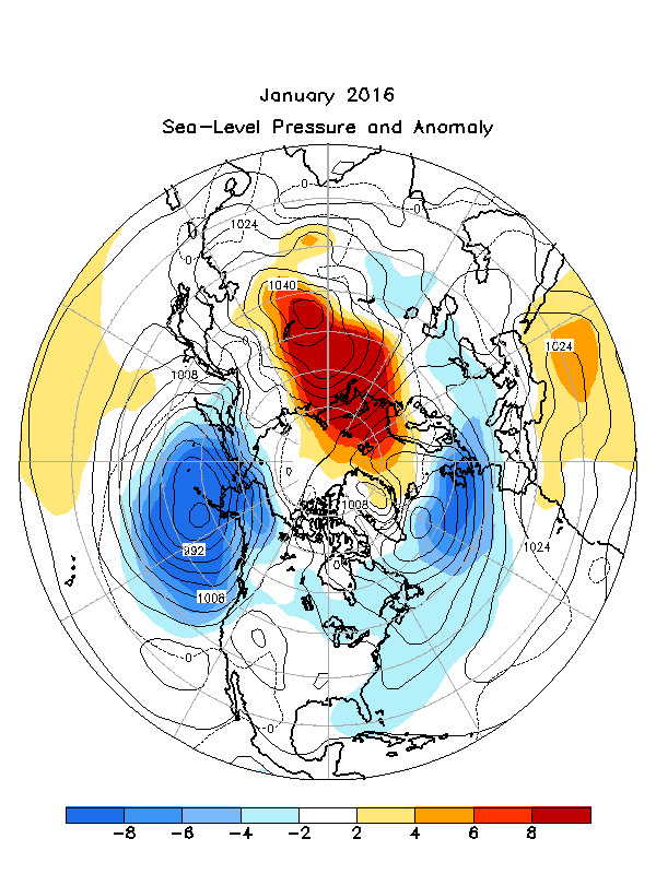
The 500 hPa mean circulation during January 2016 featured positive height anomalies across the North Polar Region and central Russia, and subtropical latitudes of the Pacific, Atlantic, and Africa. Negative height anomalies prevailed across the central North Pacific and Atlantic Oceans and Europe Figure 1. This overall anomaly pattern projected strongly onto the positive phase of the Pacific North American teleconnection pattern (PNA, +1.9). A positive PNA pattern is a typical response to El Nino. The corresponding Sea Level Pressure (SLP) and Anomaly map (Figure 2) featured below normal SLP over northeastern portions of both the Pacific and Atlantic, and above normal SLP from northern Scandinavia across central Russia to near Lake Baikal. SLP ranged from about 984 hPa near the Aleutians to 1044 hPa near Lake Baikal, a difference of 60 hPa.
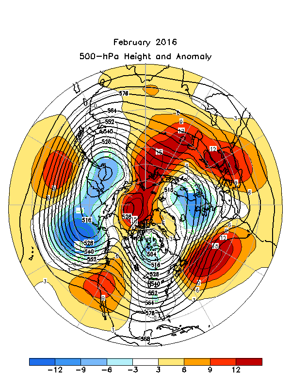
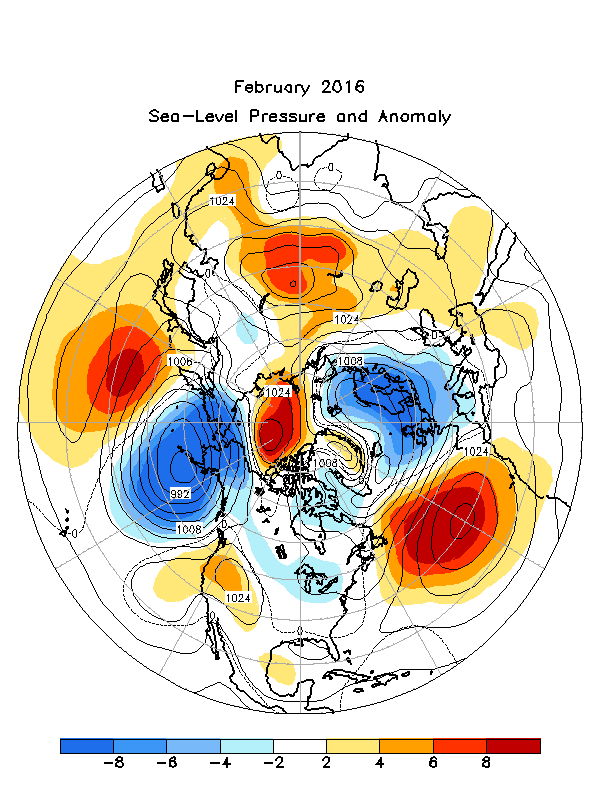
During February, 500 hPa heights were above average across the subtropical North Pacific, western North America, the North Atlantic, and from the eastern Mediterranean region to central Asia, continuing northward to (and including) the Arctic Ocean Figure 3. Below average heights were noted from the Sea of Okhotsk area to the eastern North Pacific , eastern North America, and northern Europe. The corresponding SLP and Anomaly map depicts a similar pattern that generally matches the middle tropospheric configuration in anomaly sign Figure 4.
The Tropics
Sea surface temperatures (SSTs) were above average in the central and eastern equatorial Pacific in January and February. The latest monthly Nino index for the Nino 3.4 region was +2.6C (January) and +2.4C (February). The depth of the oceanic thermocline (measured by the depth of the 20C isotherm) was above average in the eastern Pacific, as is typical during an El Nino winter. Sub surface temperatures ranged from 1-5C above average. Equatorial low level westerly wind anomalies and upper level easterly wind anomalies remained fairly strong in the central and eastern Pacific during this two month period. Tropical convection was enhanced over the central and east central Pacific, and suppressed over Indonesia and the western equatorial Pacific. Collectively, these oceanic and atmospheric anomalies reflect the continuation of a strong El Nino.
March-April 2016
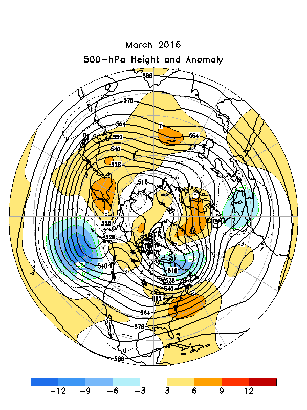
The March circulation pattern featured above average 500 hPa heights across the subtropical North Pacific Ocean, the eastern contiguous U.S., the high latitudes of the North Atlantic and Scandinavia, and central/eastern Asia Figure 5. Below average heights were noted across the eastern North Pacific, Newfoundland and the Labrador Sea, and the western Mediterranean region. The SLP and Anomaly map generally reflected the mid tropospheric height anomaly pattern Figure 6.
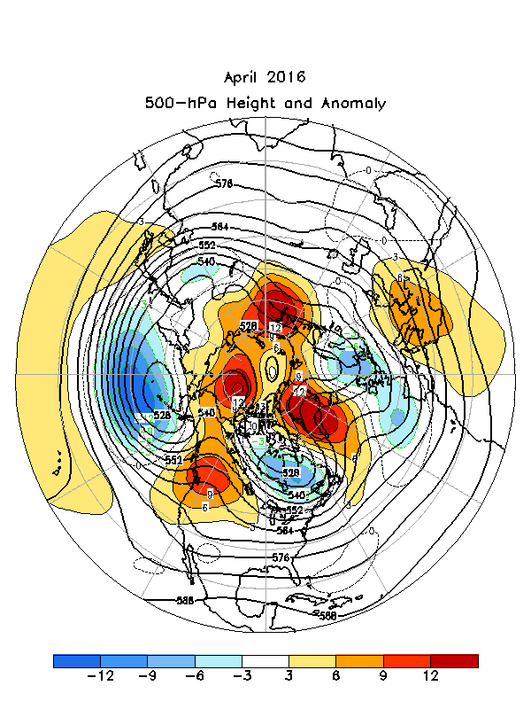
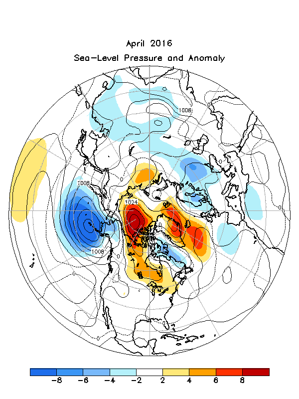
The mean 500 hPa circulation during April 2016 was characterized by above average heights across the subtropical North Pacific, the western contiguous U.S., the high latitudes of the North Atlantic and most of the north polar basin, and the Mediterranean Sea Figure 7. Below average 500 hPa heights were noted over the high latitudes of the North Pacific, eastern Canada, and the eastern North Atlantic/western Europe. The SLP and Anomaly map generally mirrors the mid tropospheric pattern Figure 8.
The Tropics
SSTs were above average in the central and eastern equatorial Pacific for the two month period, though the magnitude of the anomalies has decreased. The latest monthly Nino indices for the Nino 3.4 region were +1.7C (March) and +1.1C (April). In March, the depth of the oceanic thermocline remained above average in the far eastern Pacific, and corresponding sub surface temperatures were 1-3C above average. However, cooler than average subsurface water extended eastward across the central and east central Pacific, significantly reducing the equatorial Oceanic Heat Content (OHC) in those regions. During April, the thermocline shoaled (rose) over the central and eastern Pacific, with subsurface temperatures ranging from 1-3C below average. Low level westerly wind anomalies were slightly above average in the central and eastern Pacific in March and April. Upper level easterly wind anomalies remained strong over the central Pacific during the two month period. Tropical convection was enhanced over the central and east central Pacific (March) and the eastern Pacific (April) , and suppressed over Indonesia and the western Pacific (March and April). Collectively, these oceanic and atmospheric anomalies reflect a weakening El Nino.
Early to mid January 2016 featured two out of season hurricanes; one in the Atlantic (Alex), the other in the Central Pacific (Pali) Reference 1. This marked the first known occurrence of simultaneous January tropical cyclones, one in each basin. Alex developed from a subtropical cyclone over the eastern Atlantic, with peak sustained winds of 140 km/hr, and a minimum central pressure of 9 81 hPa. It made landfall on the island of Terceira in the Azores as a strong tropical storm, though resulting damage was somewhat less than expected. In the Central Pacific, Pali acquired peak wind speeds of 155 km/hr, and a minimum pressure of 977 hPa, remaining well away from land. Pali was also the earliest forming tropical cyclone ever recorded in the Central Pacific.
References
1. http://www.nhc.noaa.gov/data/ (historical archive)
Much of the information used in this article originates from the Climate Diagnostics Bulletin archive: (http://www.cpc.ncep.noaa.gov/products/CDB/CDB_Archive_html/CDB_archive.shtml)

Back to top