Tropical Atlantic and Tropical East Pacific Areas January through April 2015
Marshall Huffman and Andy Latto
Tropical Analysis and Forecast Branch,
National Hurricane Center, Miami, Florida
NOAA National Center for Environmental Prediction
Tropical North Atlantic Ocean including the Caribbean Sea and the Gulf of Mexico
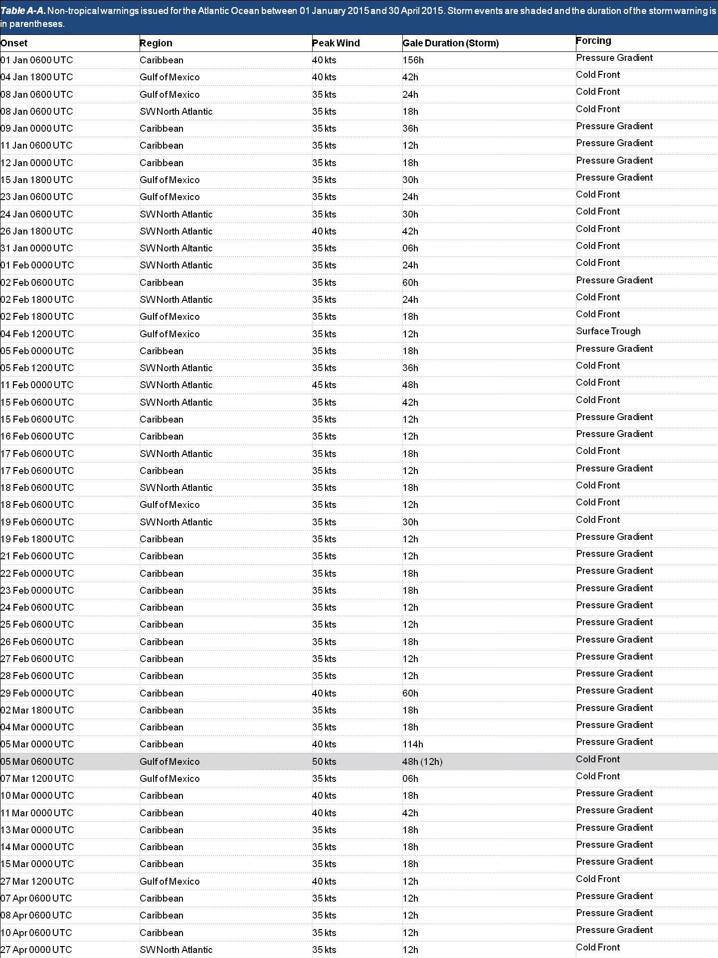
The TAFB Atlantic High Seas area of responsibility (AOR) extends from 7°N to 31°N west of 35°W, including the Caribbean Sea and Gulf of Mexico. Fifty-Three (53) gale warnings were issued for this area from January through April 2015; with only One (1) storm force wind warning and zero hurricane force wind warnings issued during the period. The Fifty-Four (54) warnings issued in the Atlantic basin was the highest number of warnings ever issued by TAFB during a winter season, breaking the previous record number of Forty-Four (44) in 2014. The number of warnings was up from the January through April five-year average of Twenty-Eight (28) warnings. Of the Fifty-Four (54) warnings issued, ten of these were located in the Gulf of Mexico, Fourteen (14) of these were located in the Atlantic Ocean, and Thirty (30) were located in the Caribbean Sea.
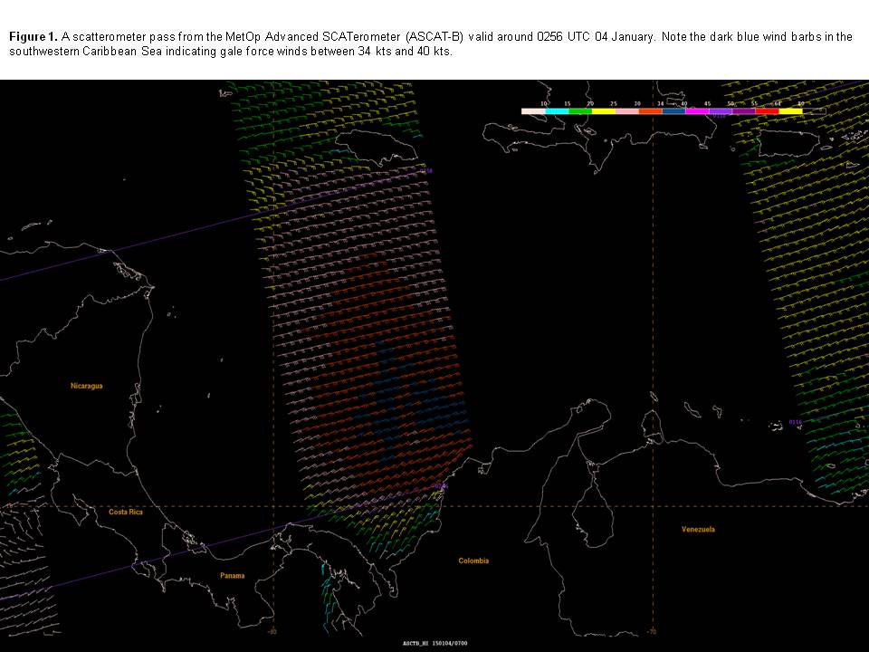
Table A-A details the warnings issued in the TAFB Atlantic High Seas AOR from January through April 2015. The first longer duration gale of 2015 began on 1 January and occurred in the Caribbean Sea as a strong pressure gradient set up between a relatively strong high pressure system anchored across the Southwest North Atlantic Ocean and lower pressure across the Northwestern South American continent. Gale force conditions persisted for six and a half days before a strong frontal trough weakened the Southwest North Atlantic ridging and relaxed the pressure gradient across the Caribbean Sea. Figure 1 shows a MetOp Advanced SCATerometer (ASCAT-B) pass from 04 January. Note the blue wind barbs indicating 34-40 kts winds in the Southwestern Caribbean Sea that reached the surface. Warnings were discontinued in the Caribbean by 1800 UTC 07 January.
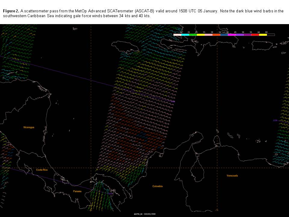
Figure 2 shows another MetOp Advanced SCATerometer (ASCAT-B) pass several hours later on 05 January indicating the gale area was not as widespread, however still occurring in a condensed area within 120 nmi off the coast of Colombia.
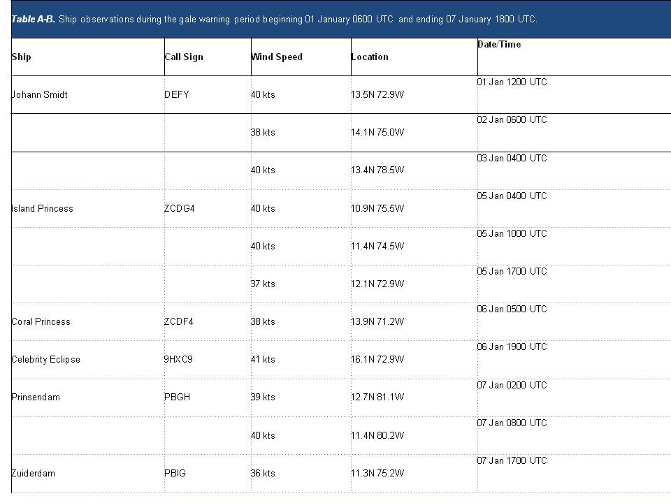
During this gale force wind event, several ships reported gale force conditions and these are summarized in Table A-B.
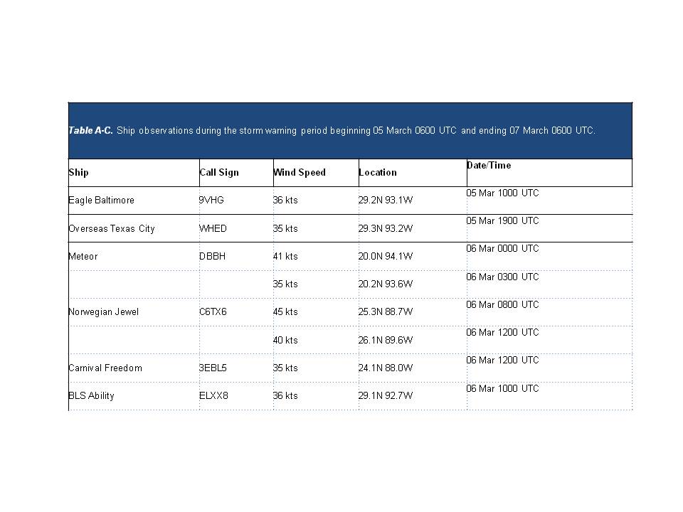
The strongest Gulf of Mexico warning was the only storm force warning that occurred across the basin in the four month period. This storm force warning began at 0600 UTC 05 March and persisted for 48 hours. Of that 48 hours, only 12 hours of storm force conditions were forecast between 0000 UTC 06 March and 1200 UTC 06 March. A strong surface pressure gradient materialized along the East-Central coast of Mexico and the Southwestern Gulf of Mexico waters after the passage of a cold front. While storm force conditions were limited to a relatively small area across the Southwestern Gulf of Mexico, Table A-C summarizes ships that reported winds of gale force or greater west of the cold front.
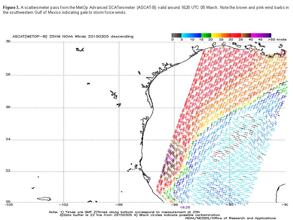
Although no storm force observations were reported, Figure 3 shows a portion of the area of gale force and storm force wind barbs offshore of Mexico south of 25N and west of 95W.
Eastern North Pacific Ocean South of 30°N and East of 140°W
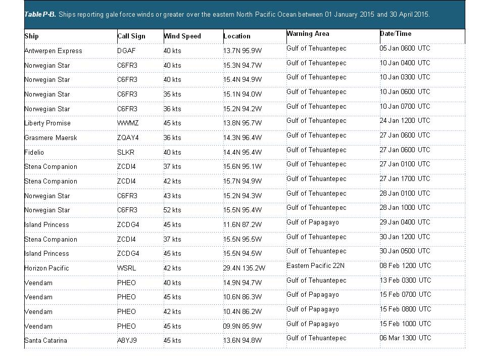
There were Twenty-Seven (27) gale or stronger events in the North Pacific east of 140W between 30N and the Equator from 01 January 2015 to 30 April 2015 summarized in Table P-A. Of these events, Twenty (20) occurred over the Gulf of Tehuantepec, Five (5) over the Gulf of Papagayo, and Two (2) over the open waters of the Pacific north of 22N. Three (3) of the events over the Gulf of Tehuantepec reached Storm Force of 50 kts or greater with ten events over this portion of the Pacific persisting 36 hours or longer at gale force. Ship observations of these gale-force or greater events are shown in Table P-B. Ship reports received through the Voluntary Observing Ship (VOS) program are a vital source of data in verifying gale and storm events.
Gulf of Tehuantepec Gale and Storm Warnings
The Gulf of Tehuantepec wind events are usually driven by mid-latitude cold frontal passages through the narrow Chivela Pass in the Isthmus of Tehuantepec between the Sierra Madre de Oaxaca Mountains on the west and the Sierra Madre de Chiapas Mountains on the east. The Northerly winds from the Southwest Gulf of Mexico funnel through the pass delivering stronger winds into the Gulf of Tehuantepec. The Thirty-Four (34) events for the Gulf of Tehuantepec this season (2014-2015) tied the record that was set just last year (2013-2014 season). However, the 936 hours of duration of gale force or higher warnings in the January through April 2015 period for the Gulf of Tehuantepec were nearly 50% greater than the 627 hours during the same period in 2014. The longest duration storm event that occurred during the January to April 2015 time period began January 4 with storm force winds lasting from early morning January 5 through the early afternoon of January 6 (a total of 36 hours) , and gale-force winds persisting until January 8.
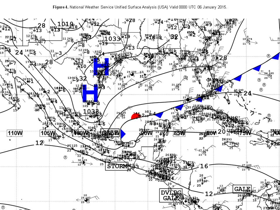
Strong high pressure over Texas (Figure 4) and northeast Mexico behind a frontal system over the Gulf of Mexico was forcing wind through the Chivela Pass and setting up this storm/gale event. During this event, the ship ANTWERPEN EXPRESS (DGAF) reported winds to 40 kts as it passed through the warned area at 0600 UTC 05 January 2015.
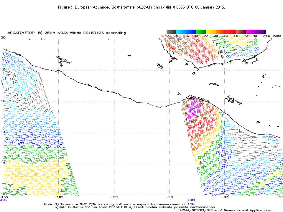
A scatterometer pass (Figure 5) captured the event with winds from 30 to 40 kts occurring north of 13.5N W of 93.5W, with a small area of winds to 45 kts near 15.5N 94.5W.
Late April to Early May Swell Event
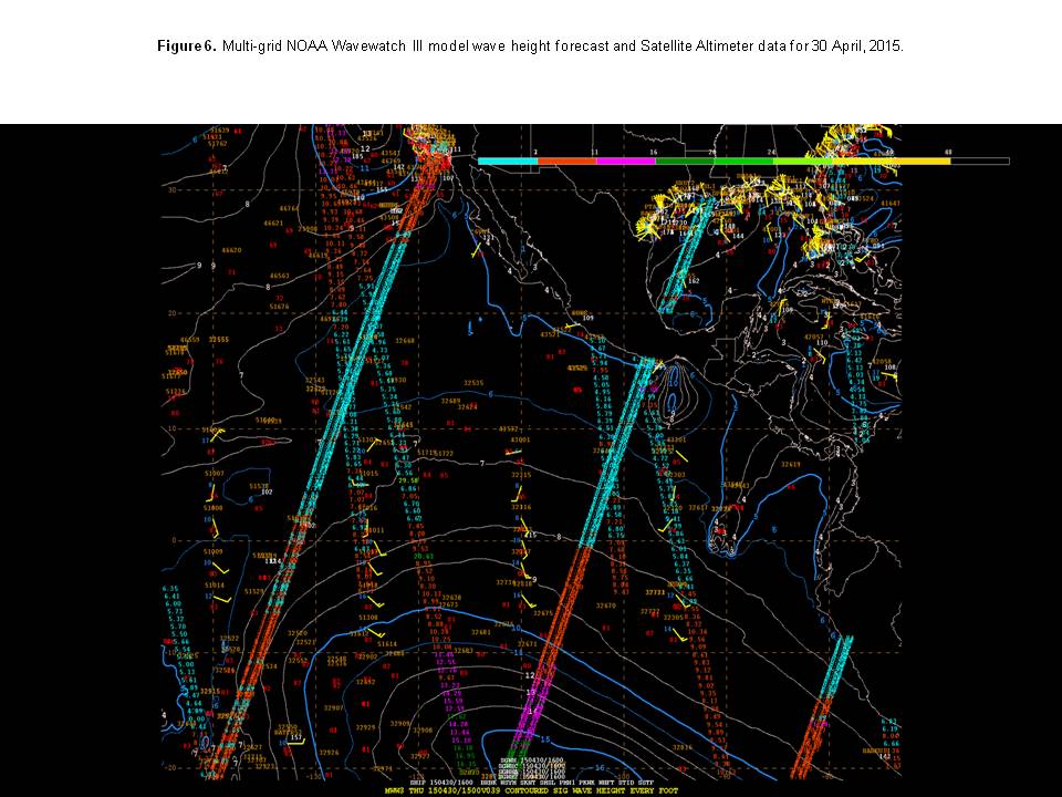
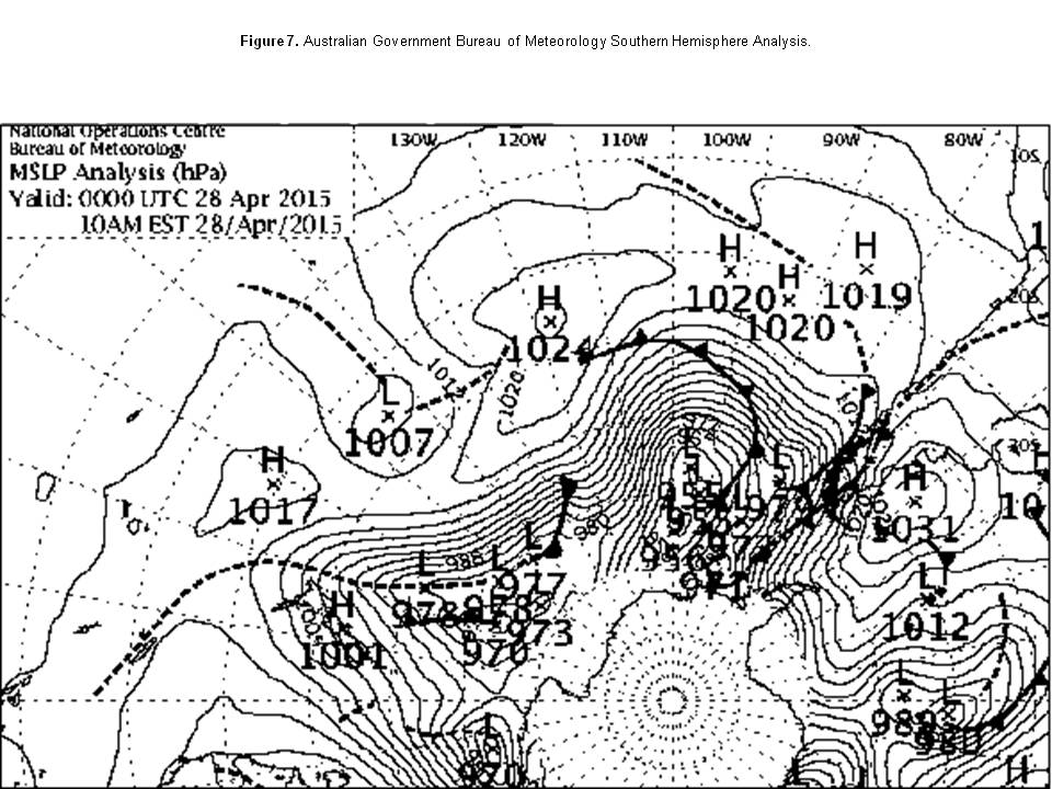
large area of swell developed over the Southern Hemisphere on 29 April, 2015, (Figure 6). On that day, 10 ft seas spanned from a line 10S 130W to 20S 130W east to 90W. Such swell was likely generated by strong winds over the open waters of the South Pacific due to a tight pressure gradient between a stronger than normal early season mid-latitude 955 hPa low along near 50S 100W, and a 1025 hPa high centered near 35S 135W.
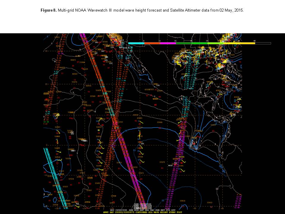
This swell (Figure 7), propagated north and east over the ensuing 48 hours, with 10-14 ft swell noted from altimeter passes between the Equator and 10N along 87W/88W on May 2. By May 3 (Figure 8) swell up to 13 feet was being measured by altimeter just offshore of the Southwestern coast of Mexico.
Northern Waters Gale Warning
A strong cold front aided by a powerful southwesterly upper jet moved across the northern portions of our observing area late February 7 to early February 8. Strong southwesterly flow ahead of the front combined with thunderstorms to produce gale force winds up to 180 nmi east of the front north of 29N which extended from 30N 135W to 25N 140W. Scatterometer data indicated winds greater than 35 ktsnorth of 28.5N and E of 138W over the open waters of the Eastern Pacific. The ship HORIZON PACIFIC (WSRL) also reported winds to 42 kts near 29.4N 135.2W at 1200 UTC 08 Feb.


