Tropical Atlantic and Tropical East Pacific Areas January through April 2014
Jessica Schauer and Marshall Huffman Tropical Analysis and Forecast Branch National Hurricane Center, Miami, Florida NOAA National Center for Environmental Prediction
Tropical North Atlantic Ocean including the Caribbean Sea and the Gulf of Mexico
The TAFB Atlantic High Seas area of responsibility (AOR) extends from 7°N to 31°N west of 35°W, including the Caribbean Sea and Gulf of Mexico. Forty three gale warnings were issued for this area from January through April 2014; with only one storm force wind warning and zero hurricane force wind warnings issued during the period. The 43 warnings issued in the Atlantic basin was the highest number of warnings ever issued by TAFB during a winter season, breaking the previous record number of 35 in 2010. The number of warnings was up from the January through April five year average of 27 warnings. Of the forty three warnings issued, fifteen of these were located in the Gulf of Mexico, sixteen of these were located in the Atlantic Ocean, and eleven were located in the Caribbean Sea.


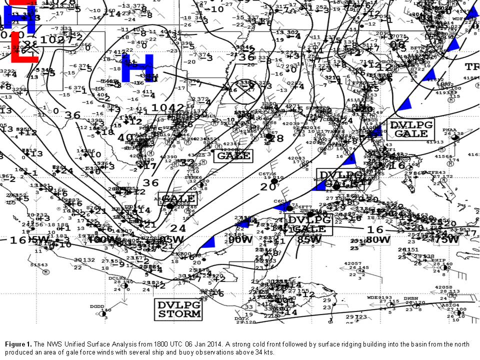
Table A-A details the warnings issued in the TAFB Atlantic High Seas AOR from January through April 2014. The first longer duration gale of 2014 occurred in the Gulf of Mexico as a strong cold front swept across the Gulf waters generating gale force conditions on 06 January and 07 January that persisted for 36 hours across western portions of the Gulf. A strong 1042 hPa high pressure system built in slowly from the north behind the cold front analyzed from the central Florida peninsula to the northwestern tip of the Yucatan peninsula as seen in Figure 1.
The pressure gradient between the ridge extending southward from the high over the U.S. southern plains into coastal northeast Mexico and the frontal boundary generated gale force winds in the southwestern Gulf. Several ships reported gale force conditions during this event, and these are summarized in Table A-B.

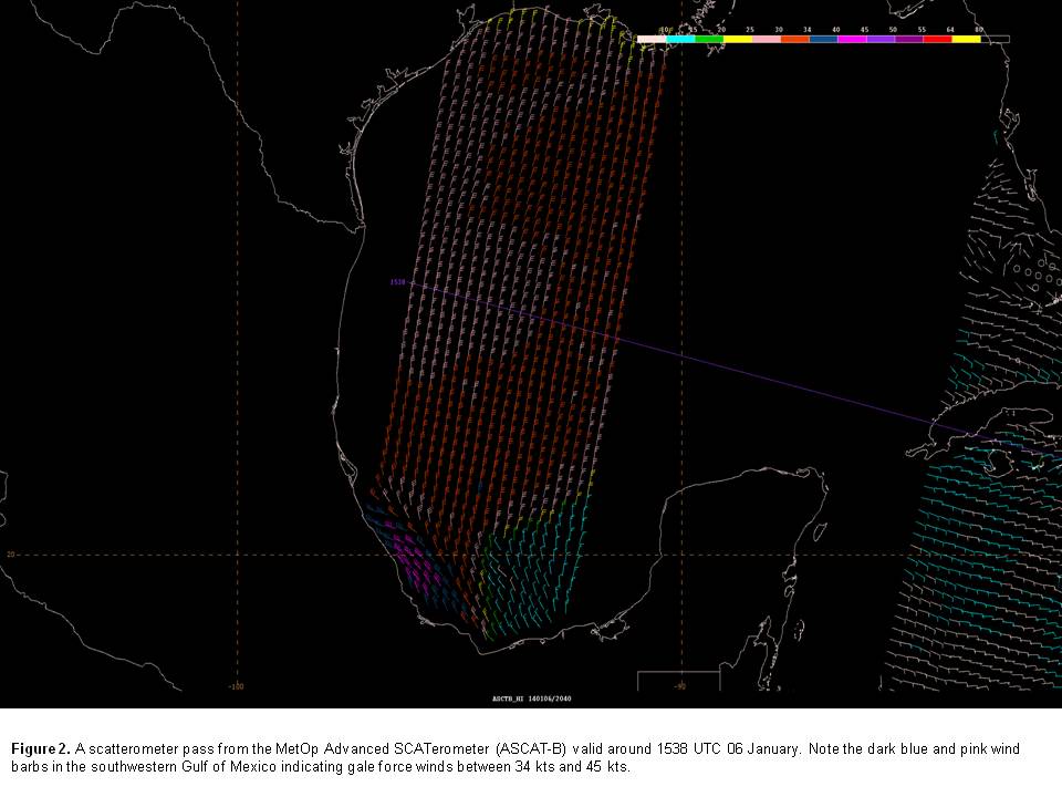
Figure 2 shows the 1538 UTC MetOp Advanced SCATerometer (ASCAT-B) pass from 06 January. Note the blue and pink wind barbs indicating 34-45 kts winds in the southwestern Gulf that reached the surface. Warnings were discontinued in the Gulf of Mexico by 1200 UTC 07 January as the cold front moved into the southwest North Atlantic region.
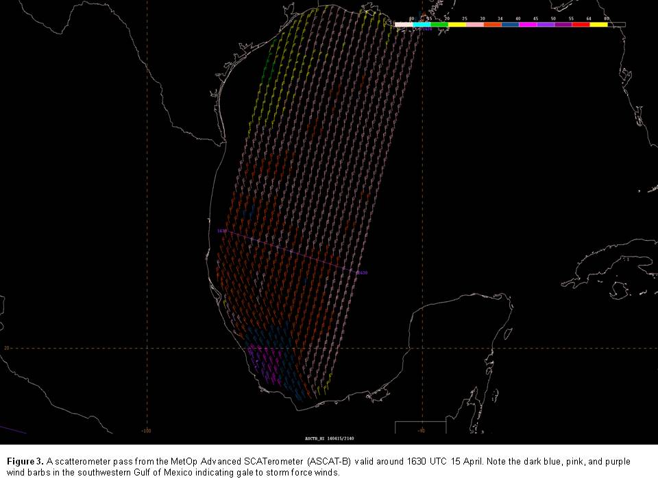
The strongest Gulf of Mexico warning was the only storm force warning that occurred across the basin in the four month period. This storm force warning began at 0000 UTC 15 April and persisted for 30 hours. Of those 30 hours, only 6 hours of storm force conditions were forecast between 1800 UTC 15 April and 0000 UTC 16 April. A strong surface pressure gradient materialized along the east-central coast of Mexico and the southwestern Gulf of Mexico waters after the passage of a cold front. While storm force conditions were limited to a relatively small area across the southwestern Gulf of Mexico as noted in Figure 3, five ships reported winds of gale force or greater. In chronological order, the Eagle Toledo (S6NK3) reported 41 kts northwest winds near 28.5N 94.5W at 0300 UTC 15 April. Two hours later at 0500 UTC 15 Apr in nearly the same location the Eagle Baltimore (9VHG) reported 46 kts north winds. Other vessels impacted by the gale force winds to the north of the storm warned area included the Overseas Texas City (WHED) reporting 40 kts, the Overseas Cascade (WOAG) reporting 48 kts, and the Deepwater Champion (YJVM9) reporting 35 kts at 1700 UTC near 28.8N 88.2W as the event was nearing termination. Although no storm force observations were reported, Figure 3 shows the area of gale force and storm force wind barbs offshore of Mexico south of 20N and west of 95W.
Eastern North Pacific Ocean South of 30°N and East of 140°W
The twenty-three events of gale force or stronger winds observed from 01 January 2014 to 30 April 2014 in the eastern North Pacific between 30°N and the equator east of 140°W are cataloged in Table P-A. All but two of these warning events were in the Gulf of Tehuantepec. There were 21 occurrences of gale force winds in the Gulf of Tehuantepec, with seven of those events producing winds of storm force. The other gale events were found in the Gulf of Papagayo and across waters north of 25°N, respectively. Table P-B catalogs the ship observations of these gale-force or greater events. Ship reports received through the Voluntary Observing Ship (VOS) program are a vital source of data in verifying gale and storm events.


Table P-B. The National Oceanic and Atmospheric Administrations (NOAA) Geostationary Operational Environmental Satellite West (GOES-W) infrared imagery overlaid with altimeter passes from the National Aeronautics and Space Administrations (NASA) Jason-2, the European Space Agencys (ESA) CryoSat-2, and the ALTIKA sensor from the Indian Space Research Organization (ISRO) and the Centre National D'études Spatiales of France (CNES) in addition to scatterometer passes from the MetOp Advanced SCATerometers A and B (ASCAT-A and ASCAT-B) and the NOAA/NASA/United States Department of Defense WINDSAT sensor aboard the Coriolis satellite valid around 1800 UTC 28 February 2014. The TAFB area of responsibility is found south of 30°N and east of 140°W denoted by the light blue lines.
Gulf of Tehuantepec Gale and Storm Warnings
The Tropical Analysis and Forecast Branch (TAFB) at the National Hurricane Center (NHC) has been recording gale-force or greater gap wind events in the Gulf of Tehuantepec since the QuikSCAT satellite began regular wind observations over the region in 1999. The 2013-14 winter season included a record number of these gap wind events in the Gulf of Tehuantepec, including two late-season May events. The thirty-three gap wind events this season broke the previous record of 24 events which occurred both in the 2003-04 and 2011-12 seasons. There were eleven storm-force wind events in 2013-14. This season ranks second in the number of storm-force wind events. The record holder remains the 2006-07 season when 13 storm force wind events occurred.
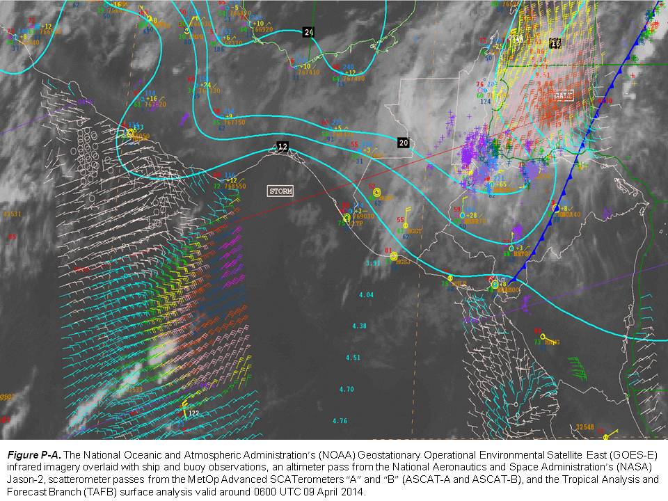
The gap wind events in the Gulf of Tehuantepec were primarily driven by mid-latitude cold frontal passages from the Gulf of Mexico through the narrow Chivela Pass into the Pacific. A strong pressure gradient between high pressure behind the front to the north of the gap wind region and lower pressure associated with the inter-tropical convergence zone (ITCZ) or monsoon trough to the south allowed some of these events to persist for as long as three days. January was the busiest month for wind events in the Gulf of Tehuantepec during the January-April observing period. Nine ships reported gale force winds in the region during January. Three of these ships, the Zim Barcelona (4XIS), the Tokyo Express (DGTX), and the Hanjin Mundra (DQVH), saw storm force winds. A strong late season storm event began 08 April at 2100 UTC. Figure P-A shows the tight pressure gradient analyzed by TAFB over Chivela Pass and scatterometer data observed 45 kts winds (purple wind barbs) well down wind of the Gulf of Tehuantepec around 0600 UTC on 09 April. The cold front that spurred this event later moved southeast through the Gulf of Papagyo.
Gulf of Papagayo Gale Warning
The only gale force wind event in the Gulf of Papagayo during the observing period occurred on the morning of 10 April 2014. 40 kts winds were reported by the Island Princess (ZCDG4) as it moved through the region. As mentioned in the section above, the particularly strong, late-season cold front that brought storm force winds to the Gulf of Tehuantepec a day earlier was responsible for the gale in the Gulf of Papagayo. Gale force winds persisted for 12 hours and were enhanced by early morning drainage flow from the mountains over northern Costa Rica and southern Nicaragua.
Northern Waters Gale Warning
On 27 February 2014, a deep layered low pressure system sent a powerful cold front into the northern portion of the observing area, with gale force winds found northward of 25°N for 42 hours. This strong low pressure system ventured farther south than the climatological mean. It was analyzed as deep as 969 hPa. Figure P-B shows gale force northwest winds (dark blue wind barbs) and seas as high as 5.8m (19 ft) south of 30°N around 1800 UTC on 28 February. The Overseas Anacortes (KCHV) provided several reports of 40-45 kts winds just north of the area between 31°N-32°N. The low eventually weakened and moved northeastward, allowing winds to drop below gale force over the observing area by the early morning hours of 01 March.
Back to top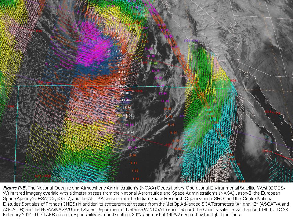