MARINE WEATHER REVIEW NORTH PACIFIC AREA September 2013 to February 2014
George P. Bancroft Ocean Forecast Branch, Ocean Prediction Center, College Park, MD NOAA National Center for Environmental Prediction
Introduction
The weather pattern over the North Pacific was active during the early fall months of September and October as a series of cyclones moved northeast out of the western Pacific near Japan to the Bering Sea or just south the Aleutian Islands to the Gulf of Alaska, with some developing storm force winds. Some of these included former western North Pacific tropical cyclones. Other developing lows moved out of the central or eastern North Pacific toward the Gulf of Alaska. A storm at the end of October that moved into the Bering Sea at the beginning of November was the first one with non-tropical origin to produce hurricane force winds based on analysis using observations, satellite imagery and model data. Later in November and through February increased blocking in the northeastern Pacific or at high latitudes resulted in cyclones coming out of the central and western North Pacific to stall or turn northwest into the Bering Sea or sometimes move west of the Kamchatka Peninsula. The most active month was January, producing six hurricane force lows. Three cyclones developed central pressures as low as 948 hPa, with one each occurring in the months of November to January. Tropical activity in the northwestern Pacific including cyclones appearing on OPC oceanic surface analyses was concentrated in September and October, with one tropical depression, two tropical storms, four typhoons and two super-typhoons occurring. Of these, four became strong post-tropical (extratropical) lows as they entered the mid-latitude westerlys. The most significant of these was Wipha, producing hurricane force winds while moving from near Japan to the western Bering Sea.
Tropical Activity
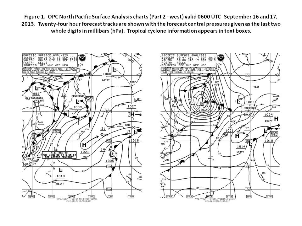
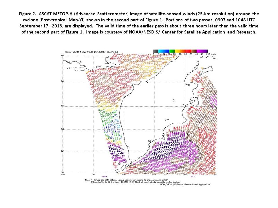
Tropical Storm Man-Yi: A non-tropical low near 19N 147E at 0000 UTC September 11th tracked west-northwest and slowly strengthened, developing gale force winds early on the 12th and then becoming upgraded to a tropical storm late on the 12th near 22N 143E with maximum sustained winds 35 kt with gusts to 45 kt. Tropical Storm Man-Yi became strongest when passing south of Japan near 32N 136E early on the 15th with maximum sustained winds 60 kt with gusts to 75 kt. Man-Yi then began to weaken while turning toward the northeast, passing near the east coast of Japan and becoming a post-tropical storm off northern Japan early on the 16th. Figure 1 shows Man-Yi in extratropical transition to a powerful storm force low near maximum intensity with a central pressure of 962 hPa near the Kamchatka Peninsula. The ASCAT-A image in Figure 2 shows gale and storm force winds affecting portions of the Sea of Okhotsk and western Bering Sea, with some of the wind barbs, up to 55 kt, indicating actual winds south of the storm center approaching hurricane force due to low bias of ASCAT at higher wind speeds. The ship UPAB (53N 144E) reported northwest winds of 50 kt and 3.7 m seas (12 feet) at 0600 UTC on the 18th. The cyclone moved north and developed a lowest central pressure of 960 hPa before weakening in the far northwest Bering Sea on the 18th and 19th, where winds diminished to below gale force.
Typhoon Pabuk: A non-tropical low with gale force winds moved north along 148E into OPCs radio facsimile Pacific chart area late on September 19th and became a tropical storm with maximum sustained winds of 35 kt near 21N 145E at 0600 UTC on the 21st. Tropical Storm Pabuk moved slowly northwest over the next two days and intensified to a typhoon near 26N 140E at 1200 UTC on the 23rd with maximum sustained winds of 65 kt with gusts to 80 kt. After Pabuk developed a maximum intensity of 90 kt for sustained winds when passing 350 nm south of Tokyo late on the 24th, the cyclone weakened to a tropical storm late on the 25th and then became post-tropical early on the 26th. Buoy 28401 (32.4N 144.5E) reported southwest winds of 50 kt at 0400 UTC on the 26th. Post-tropical Pabuk then gradually weakened and turned east along 49N, passing south the western and central Aleutian Islands as a gale before turning southeastward and dissipating south of the eastern Aleutians early on the 30th.
Tropical Storm Sepat: A non-tropical low, stationary near 21N 159E on September 26th , began moving northwest on the 27th and became a tropical depression (21W) at 0000 UTC on the 30th near 26N 147E with maximum sustained winds of 30 kt with gusts to 40 kt. Thirty hours later, the cyclone was upgraded to Tropical Storm Sepat near 30N 140E with maximum sustained winds 35 kt with gusts to 35 kt. Sepat then turned toward the north while maintaining this intensity before becoming a post-tropical gale near 36N 142E at 0600 UTC October 2nd. Post-tropical Sepat briefly developed storm force winds with a 995 hPa center near 49N 151E 24 hours later. The Tokyo Express (DGTX) encountered south winds of 40 kt near 35N 146E at 1200 UTC on the 2nd. The cyclone then moved into the western Bering Sea as a gale on the 3rd before moving inland over Russia on the 4th.
Typhoon Danas: A stationary low formed late on October 1st near 17N 150E and developed tropical characteristics late on the 2nd, to become a tropical depression (23W) early on the 3rd and Tropical Storm Danas near 17N 145E at 0600 UTC on the 4th with maximum sustained winds 35 kt with gusts to 45 kt. Danas drifted northwest and continued to strengthen, becoming a typhoon with sustained winds to 65 kt near 19N 140E 1200 UTC on the 5th. Danas developed an intensity of 105 kt for sustained winds with gusts to 130 kt while passing near 24N 131E at 1800 UTC on the 6th. This intensity is at category 3 on the Saffir-Simpson intensity scale (Reference 4), making Danas a major typhoon. The cyclone passed west of the area shortly thereafter.
Typhoon Wipha: Wipha was already a strengthening typhoon upon passing north of 17N into OPCs radio facsimile oceanic chart area near 18N 138E early on October 12th with maximum sustained winds of 65 kt with gusts to 80 kt. Twenty-four hours later the cyclone developed a peak intensity of 115 kt for sustained winds with gusts to 140 kt near 24N 134E, placing it in a low end category 4 on the Saffir-Simpson scale (highest being 5). A weakening trend and a northeastward turn then set in, along with extratropical transition. Figure 5 shows Wipha six hours prior to becoming post-tropical and in the second part as a powerful post-tropical low. Wipha was a major event in the northwestern Pacific due to its size, intensity and waves generated. Post-tropical Wipha maintained hurricane force winds until it reached the southern Bering Sea just north of the western Aleutians late on the 17th. The peak intensity of 960 hPa occurred on the morning of the 16th near the central Kurile Islands. The cyclone weakened to a gale near Saint Paul Island but still with a 968 hPa center 0000 UTC on the 19th. Dissipation followed late on October 22nd in the northern Bering Sea. Selected ship reports taken in this event are listed in Table 1.
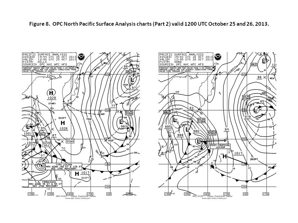
Super-Typhoon Francisco: A super-typhoon has sustained winds of 130 kt or more. One of two during the fall season, Francisco, moved north into OPCs radio facsimile chart area near 17N 140E at 0600 UTC October 19th at maximum intensity with sustained winds to 140 kt and gusts to 170 kt. This is category 5, the highest on the Saffir-Simpson hurricane scale. Francisco maintained this intensity while moving to 19N 137E over the next 24 hours. The cyclone then began a weakening trend as it became a minimal typhoon while passing west of 130E early on the 23rd and then re-curved northeast into the area as a tropical storm near 27N 131E at 1800 UTC on the 24th with maximum sustained winds 60 kt with gusts to 75 kt. Figure 8 shows Francisco linking with a front to become a 988 hPa post-tropical low over a 24 hour period. The Westwood Columbia (C6SI4) reported north winds 45 kt and 7.0 mseas (23 feet) at 0000 UTC on the 26th. Francisco briefly re-intensified to a storm force low on the 27th near the Kurile Islands and then tracked east into the central North Pacific as a gale before becoming absorbed late on the 29th south of the Aleutian Islands.
Super-Typhoon Lekima: Tropical Storm Lekima developed from a stationary non-tropical low near 11N 161E at 1800 UTC October 20th then moved northwest, intensifying to a minimal typhoon 24 hours later near 14N 159E and to a super-typhoon near 18N154E at 1800 UTC on the 22nd with maximum sustained winds of 140 kt with gusts to 170 kt. Lekima remained a super-typhoon until early on the 24th when it began to turn toward the north and then northeast and weaken. The intensity was down to 70 kt for sustained winds near 37N 152E at 0600 UTC on the 26th six hours before becoming a post-tropical hurricane force low six hours later (Figure 8) with fronts. An ASCAT-B image returned southeast winds of 50 kt on the west edge of a 0949 UTC October 26th pass and likely missed higher winds in a gap between passes. The MSC Malta (A8GA8) near 34N 160E encountered west winds of 35 kt and 7.0 m seas (23 feet) at 0600 UTC on the 27th. The cyclone moved east and began to weaken on the 26th with winds easing to gale force early on the 27th. After passing 180W the cyclone moved northeast and re-intensified to 968 hPa near Kodiak Island late on the 29th where it briefly developed storm force winds. Post-tropical Lekima then stalled and weakened in the northern Gulf of Alaska on the 30th and 31st and dissipated November 1st .
Tropical Depression 27W: Short-lived T.D. 27W formed near 20N 149E at 0600 UTC October 19th with maximum sustained winds of 25 kt with gusts to 35 kt. The cyclone moved southwest for the first 12 and then turned toward the northwest and dissipated as a remnant low near 25N 143E early on the 20th.

Other Significant Events of the Period
Northeastern Pacific Storm, September 5-6: Low pressure originating near 39N 164W early on the 4th moved northeast and then turned north through the Gulf of Alaska late on the 5th and on the 6th. Storm force winds occurred on the 6th with the cyclone developing a lowest central pressure of 980 hPa near 55N 153W at 1800 UTC on the 6th. ASCAT-B imagery at 2057 UTC on the 6th showed southwest winds as high as 45 kt at the west edge of a pass south of Kodiak Island. The APL Canada (A8CG6) near 53N 153W reported west winds of 40 kt and 5.8 m seas (19 feet) at 1800 UTC on the 6th. The cyclone weakened rapidly as it moved onshore near the Kenai Peninsula the following night.
North Pacific Storm, September 6-9: A cyclone slightly deeper than the Gulf of Alaska event mentioned above originated in the Sea of Okhotsk early on September 5th and tracked east between 49N and 51N over the next three days, developing storm force winds and a lowest central pressure of 977 hPa while passing south of the central Aleutian Islands late on the 7th. The cyclone then weakened while turning north into the southeast Bering Sea and then inland over southwest mainland Alaska on the 9th and 10th.
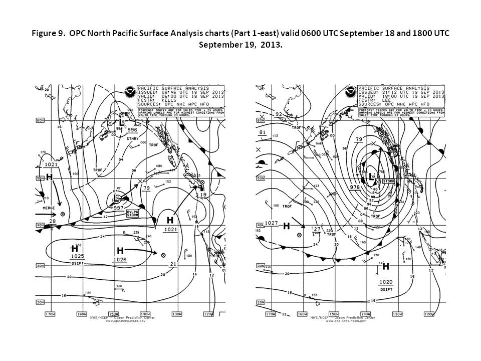
Northeastern Pacific Storm, September 17-20: Figure 9 depicts the development of this storm. A wave of low pressure near 45N 162W at 1800 UTC on the 17th moved northeast while deepening rapidly over the next 24 hours, with the central pressure falling 30 hPa. The cyclone developed a lowest central pressure of 970 hPa near 51N 137W at 0000 UTC on the 20th. Storm force winds occurred over a 36 hour period ending at 0600 UTC on the 20th. At 0900 UTC on the 19th the Westerdam (PINX) near 53N 130W reported southeast winds of 60 kt and 4.0 m seas (13 feet). The Star Princess (ZCDD6) at 1500 UTC on the 19th and the Zuiderdam (PBIG) at 1800 UTC on the 19th observed southeast winds of 60 kt at 55N 132W, with the Star Princess also reporting 4.9 m seas (16 feet). The Amsterdam (PBAD) near 53N 129W encountered southeast winds 55 kt at 1300 UTC on the 19th. The MSC Texas (DCSY2) observed the highest seas, 9.8 m (32 feet) along with northwest winds of 40 kt near 46N 155W at 1200 UTC on the 18th. The cyclone then moved north-northwest and onshore near 60N 140W with winds below gale force early on the 21st.
North Pacific/ Bering Sea Storm, September 19-24: Another rapidly intensifying low originating near 42N 160E at 0000 UTC September 19th moved to near the western Aleutian Islands 24 hours later and then to the eastern Bering Sea in the following 24 hour period, when the central pressure dropped 34 hPa, with the low developing storm force winds at that time. The central pressure dropped as low as 965 hPa near Kodiak Island 12 hours later, making it the deepest low with non-tropical origin in September and October. An ASCAT-B pass from 0656 UTC on the 21st returned winds from the west to northwest up to 50 kt on the eastern edge of the pass south of the Alaska Peninsula. As the cyclone crossed the Gulf of Alaska the winds diminished to gale force early on the 23rd and to below gale force on the 24th.
Northeast Pacific Storms, September 25-30: A low pressure wave moved from northern Japan to the western Bering Sea late on September 24th and on the 25th with gale force winds, and then turned eastward, developing storm conditions when passing near 59N 159W with a 972 hPa central pressure at 1200 UTC on the 27th. The center moved into the northern Gulf of Alaska six hours later with a lowest central pressure of 968 hPa. The cyclone moved across the Gulf of Alaska and stalled near the Queen Charlotte Islands late on the 28th through the 30th while slowly weakening but with winds not dropping to below storm force until the 30th. Additionally, another developing low formed near 49N 156W on the 28th and moved east southeast before turning northeast and briefly developing storm force winds near Vancouver Island with a central pressure as low as 973 hPa late on the 29th before moving inland. At 0300 UTC on the 29th the Polar Adventure (WAZV) near 44N 128W reported west winds of 45 kt and, at 2000 UTC that day, 8.2 m seas (27 feet) near 47N 130W. The USCGC Healy (NEPP) 56N 154W reported northwest winds of 50 kt and 4.6 m seas (15 feet) at 1200 UTC on the 30th. The Kennicott (WCY2920), near 59N 153W, encountered northwest winds of 50 kt at 0900 UTC on the 29th. The drifting buoy 46246 (50N 144.7W) , reported seas of 9.4 m (31 feet) at 2300 UTC on the 28th.
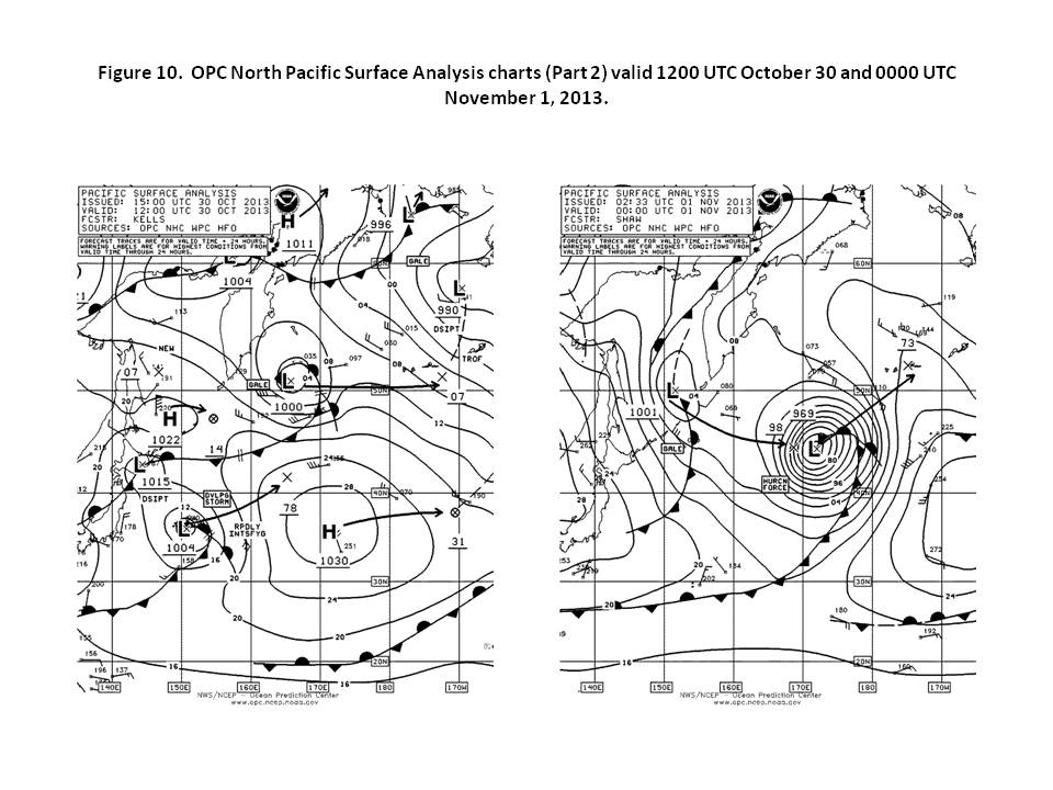
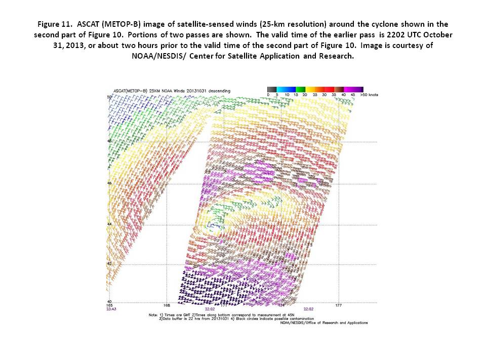
North Pacific Storm, October 30 to November 2: A wave of low pressure moved from near Japan on the 29th northeast to the central waters near 45N 172E on the afternoon of the 31st where it developed hurricane force winds (Figure 10 and the ASCAT-B image in Figure 11 showing an area of west winds 50 to 60 kt south of a well defined center). This was the first hurricane force low of the fall season that did not have tropical origins. The cyclone developed a lowest central pressure of 966 hPa 0600 UTC November 1st after which it moved northeast toward the Bering Sea with gradual weakening, with winds diminishing to below gale force in the eastern Bering Sea early on the 2nd. The low dissipated inland on the 3rd. A vessel using the SHIP call sign reported southeast winds of 45 kt near 50N 174W at 1200 UTC on the 1st.
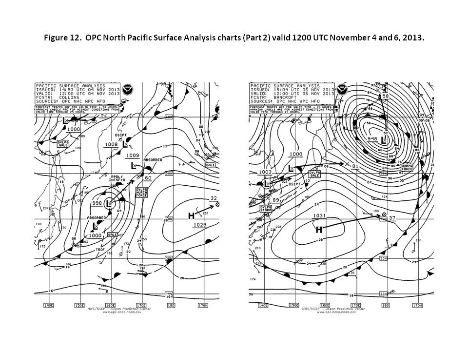
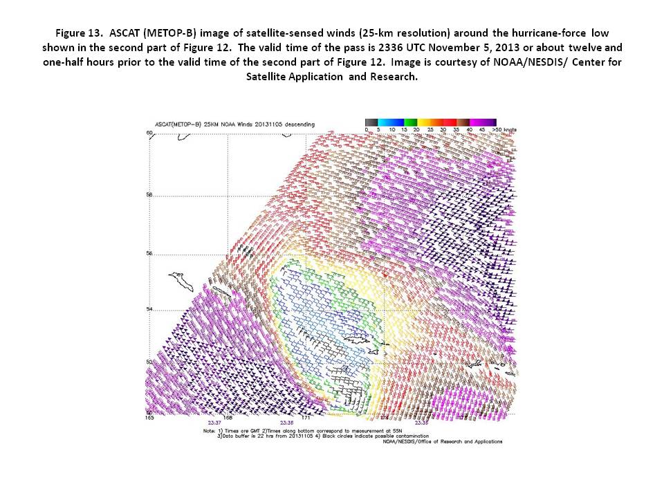
North Pacific and Bering Sea Storm, November 4-7: A complex area of low pressure with multiple centers near Japan early on November 3rd consolidated over the next two days while moving northeast toward the Bering Sea, merging into a single storm center 49N 169E with a 960 hPa center at 1200 UTC on the 5th, with the pressure falling 38 hPa in the preceding 24 hour period. The cyclone developed a lowest central pressure of 948 hPa in the central Bering Sea 24 hours later (Figure 12). This, along with two other cyclones occurring later, was the deepest non-tropical cyclone in the North Pacific during the six month period. It was the deepest in a series of cyclones to move through the Bering Sea in the first half of November. The ASCAT-B pass for 2336 UTC on the 5th (Figure 13) actually has the higher winds ahead of the Bering occluded front, up to 65 kt, and northwest winds to 55 kt south of the western Aleutians. Shemya Island, a land station, reported northwest winds of 52 kt with gusts to 63 kt at 0751 UTC on the 6th, and a peak gust 69 kt at 0856 UTC on the 6th. St. Paul Research (KEY796, 57N 170W) reported southeast winds of 60 kt at 1800 UTC on the 6th. A vessel with the SHIP call sign near 57N 167E, encountered west winds 50 kt at 0000 UTC on the 7th. Buoy 46070 (55.1N 175.3E) reported a maximum significant wave height of 13.4 m (44 feet) at 2000 UTC on the 6th. The cyclone subsequently move north and inland over Russia by early on the 7th but winds over the Bering Sea did not drop to below storm force until the afternoon of the 7th.
Northeastern Pacific Storm, November 6-7: Low pressure formed west of the Oregon offshore waters on the morning of November 6th and moved northeast to Vancouver Island in 24 hours, resulting in a small but potent cyclone producing storm force winds. The lowest pressure in a six hourly analysis was 993 hPa but a drifting buoy 46761 (49.0N 129.3W reported a pressure of 989.6 hPa at 1200 UTC on the 7th. The Horizon Anchorage (KGTX) near 50.5N 130W reported northeast winds of 60 kt at 0900 UTC on the 7th. Buoy 46132 (49.7N 127.9W) reported southeast winds 37 kt with gusts to 49 kt and 5.0 m seas (16 feet) at 0600 UTC on the 7th. The cyclone moved inland later that day.
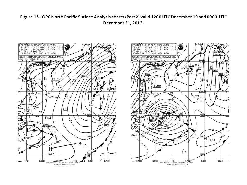
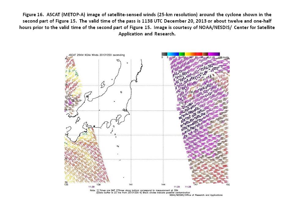
Western North Pacific Storm, December 19-23: Figure 15 depicts the low latitude development of this hurricane force low over a 36 hour period. It originated south of Japan late on December 17th. The central pressure fell 36 hPa in the 24 hour period ending at 1200 UTC on the 20th, impressive for such a low latitude development. The ASCAT-A image in Figure 16 with data missing on the west side does show winds as high as 60 kt south of the center. Rain contamination may be an issue with some wind directions off north of the center. The top winds lowered to storm force early on the 21st as the center drifted northeast, but the central pressures remained around 960 hPa until the 23rd, when the lowest central pressure of 958 hPa was reached, near 48N 170E at 1200 UTC on the 23rd. The APL India (A8JX7) near 40N 143E reported north winds of 50 kt and 7.6 m seas (25 feet) at 2100 UTC on the 20th. A vessel with the SHIP call sign encountered west winds of 55 kt and 16.5 m seas (54 feet) near 34N 148E at 1500 UTC on the 20th. The Sea-Land Comet (WDB9950) near 53N 162E reported northwest winds 45 kt and 9.4 m seas (31 feet) at 0200 UTC on the 23rd. The cyclone moved slowly north into the southern Bering Sea on the 25th, where it dissipated.
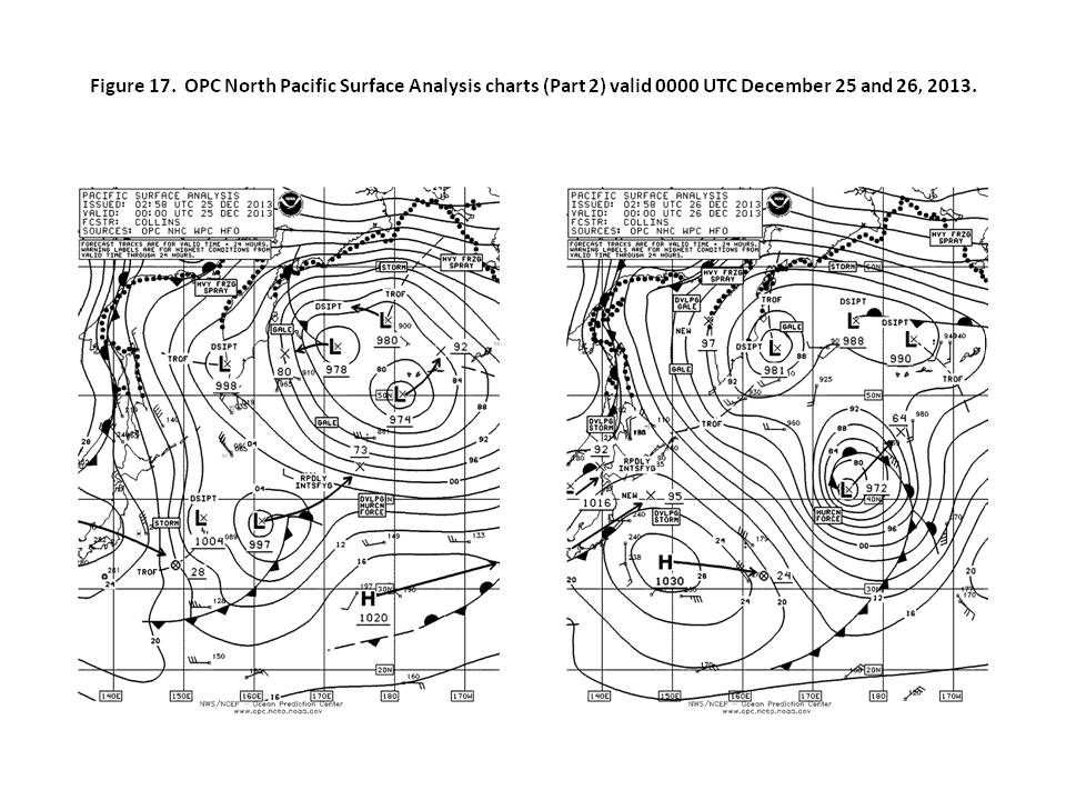
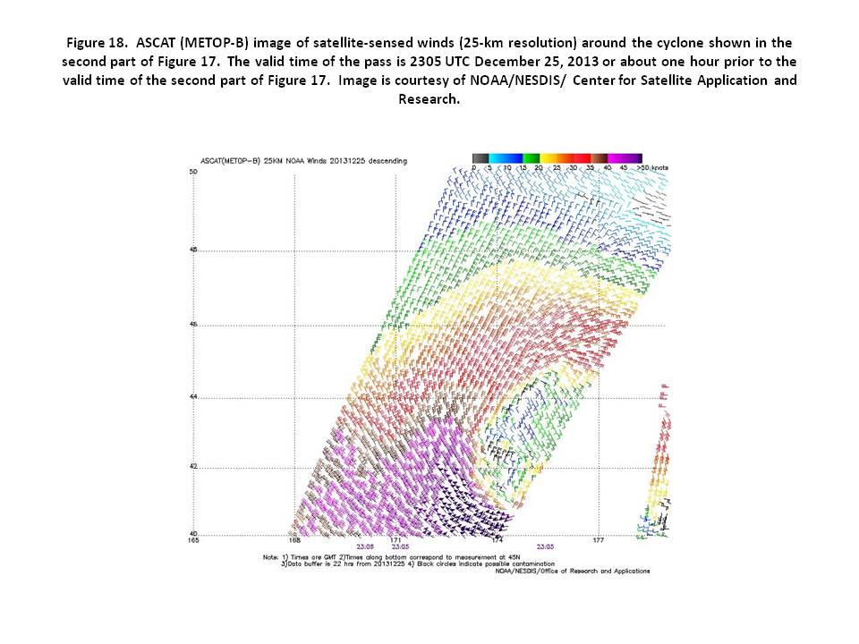
North Pacific Storm, December 24-27: Low pressure originating just south of Japan late on December 22nd tracked east-northeast to the central North Pacific on the 25th, where it developed hurricane force winds (Figure 17). The ASCAT-B image in Figure 18 valid near the time of the second part of the figure reveals winds as high as 70 kt on the west side of the center. The cyclone center developed a lowest central pressure of 960 hPa near 47N 178W at 0000 UTC on the 27th, and hurricane force winds lasted until then. The APL China (WDB3161) encountered south winds of 45 kt and 8.5 m seas (28 feet) near 39N 161W at 2100 UTC on the 26th. Weakening set in as the center turned toward the east late on the 26th with the winds diminishing to below gale force late on the 28th when the cyclone turned northeastward. The center became absorbed by another low to the west by the 30th.
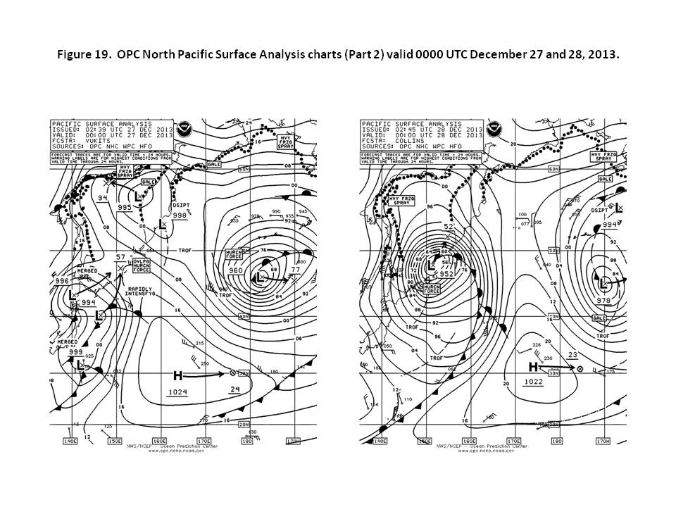
Northwestern Pacific Storm, December 26-29: Figure 19 shows the rapid development of a hurricane force low near the Kurile Islands from a complex of lows over and to the east of Japan over a 24 hour period. The central pressure fell 42 hPa during this period based on the pressure of the low near 40N147E. Six hours later the cyclone developed a lowest central pressure of 948 hPa, the second of three lows of the same intensity. ASCAT-A passes from 27/2310 UTC and 28/1129 UTC showed winds in the east semicircle and the southwest quadrant of the low, respectively, up to 60 kt. The Lowlands Phoenix (9HIY9) near 46N 151E reported southwest winds of 45 kt and 9.8 m seas (32 feet) at 0000 UTC on the 28th. Nine hours later the RDO Concord (A8TG2) reported northwest winds of 60 kt and 10.1 m seas (33 feet) near 47N 152E. The cyclone subsequently drifted north and then northwest over the Sea of Okhotsk and weakened over the next four days and dissipated late on the 31st.
Eastern North Pacific Storm, January 1-3: A wave of low pressure formed southeast of Japan near 28N 165E late on December 30th and moved rapidly northeast, not developing stor force winds until reaching 160W late on January 1st, where it slowed and drifted east. The cyclone briefly developed hurricane force winds with a 978 hPa center near 40N 159W at 1800 UTC on the 2nd. An ASCAT-A pass from three hours later returned an area of northwest winds 50 to 60 kt on the west side and winds up to 50 kt on the northeast side of the center. The APL Phillipines (WCX8884) near 45N 149W encountered southwest winds of 55 kt and 6.1 m seas (20 feet) at 0600 UTC on the 3rd. After reaching a maximum intensity of 972 hPa in terms of central pressure and not winds six hours later, the cyclone drifted east and became absorbed by a gale to the north near the Alaska Peninsula late on the 4th.
Northwestern Pacific and Bering Sea Storm, January 3-4: In this short lived event, low pressure formed near 49N 172E with a 980 hPa central pressure at 0600 UTC on the 3rd and moved into the central Bering Sea eighteen hours later with a lowest central pressure of 957 hPa and storm force winds. The cyclone then turned toward the west and, after briefly reaching hurricane force strength six hours later, weakened and crossed the Kamchatka Peninsula late on the 4th with winds diminishing to below gale force. An ASCAT-A pass from 0952 UTC on the 4th revealed northeast winds up to 55 kt on the north side near the Russian coast.
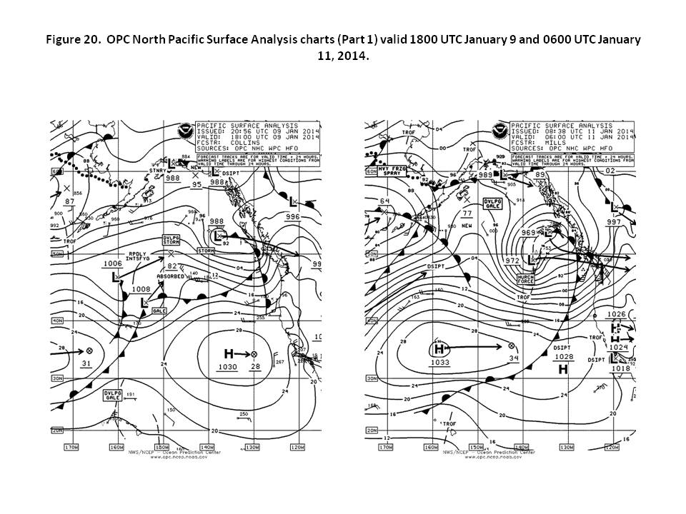
Northeastern Pacific Storm, January 9-11: A complex of lows well south of Kodiak Island at 1800 UTC on the 9th (Figure 20) consolidated into a hurricane force low near 49N 149W with a 976 hPa center 24 hours later, and the second part of Figure 20 shows the system becoming complex once again. ASCAT-A imagery from 0542 UTC on the 11th reveals an area of northwest winds to 55 kt to the west of the southern low center. The Kodiak (KQXZ) near 50N 137W reported southeast winds of 60 kt and 7.3 m seas (24 feet) at 1800 UTC on the 10th.. The CMA CGM Orfeo (9HA3487) encountered west winds of 50 kt near 43N 140W at 0000 UTC on the 11th. Buoy 46036 (48.4N 133.9W) at 1600 UTC on the 11th reported northwest winds of 41 kt with gusts to 51 kt and 6.5 m seas (21 feet), and five hours later reported highest seas at 8.5 m seas (28 feet). The cyclone then weakened inland over British Columbia later on the 11th.
North Pacific Storm, January 12-15: A new low formed on a front moving off Japan near 35N 142E 0000 UTC on the 12th and moved east-northeast, developing storm force winds late on the 12th and hurricane force winds with a relatively compact 976 hPa cyclone in the central waters near 42N 180W at 1200 UTC on the 14th. A 14/2111 UTC ASCAT-B pass returned a small area of west winds 50 to 60 kt on the southwest side near the pass edge. The cyclone moved northeast while maintaining pressures in the 970s but winds weakened to gale force on the 15th, and the system became absorbed by a new low approaching from the south later that day.
North Pacific Storm, January 15-19: Low pressure originating down near 27N 152E 0000 UTC on the 16th moved northeast and rapidly developed into a hurricane force low eighteen hours later near 36N 167E with a 982-hPa center. Figure 21 shows the relatively compact circulation in the central waters. Figure 23 is an ASCAT-A pass showing a large area of winds 50 to 65 kt on the south and west sides. The cyclone moved northeast and reached a maximum intensity of 956 hPa near 50N 158W at 1200 UTC on the 19th before top winds weakened to storm force six hours later and to gale force early on the 20th. The low turned northwest into the Bering Sea on the 20th and 21st and then dissipated late on the 22nd. The London Express (DPLE) near 55N 156W reported east winds of 50 kt at 1200 UTC on the 19th. The Penang Senator (DQVH) encountered northeast winds of 50 kt and 10.7 m seas (35 feet) near 54N 159W six hours later. Buoy 46066 (52.8N 155.0W) reported southeast winds 39 kt with gusts to 51 kt and 7.5 m seas (25 feet) at 1800 UTC on the 19th, and highest seas 10.5 m (34 feet) three hours later.
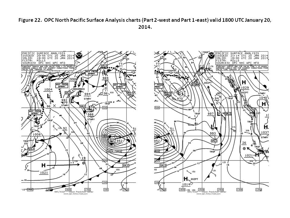
North Pacific Storm, January 19-21: The next significant event followed a track similar to that of the January 15th -19th storm, with Figure 22 showing a somewhat larger and more intense system. It originated as a new low at 27N 144E 1800 UTC on the 17th (Figure 21). An ASCAT-B pass from 20/2049 UTC showed winds 50 to 60 kt in a pattern similar to Figure 23 but may miss higher winds between passes. The cyclone developed a lowest central pressure of 948 hPa near 41N 166W at 1200 UTC on the 21st, the third cyclone with this pressure during the six month period. The Sea-Land Lightning (WDB9986) near 49N 163W encountered north winds of 40 kt and 6.7 m seas (22 feet) at 1200 UTC on the 22nd. The cyclone moved northeast and then north along 160W with winds weakening to gale force by the 22nd. The low turned northwest into the Bering Sea on the 23rd and dissipated on the 25th.
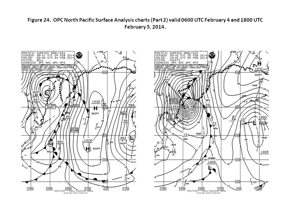
Northwestern Pacific Storm, February 4-6: A deep cyclone similar in intensity to the November 9th-11th event moved into the Sea of Okhotsk as depicted in Figure 24. It originated near southern Japan early on the 2nd and moved east before turning north near 150E over the next three days. The central pressure fell 30 hPa in the 24 hour period ending at 1200 UTC on the 5th. The OOCL Beijing (VRIB3) reported south winds of 35 kt and 11.6 m seas (38 feet) near 37N 160E at 0000 UTC on the 5th. The Lutoga (UFLC), near 49N 147E, reported northwest winds of 50 kt 12 hours later. An ASCAT-A pass valid near 0000 UTC on the 6th showed winds 50 to 65 kt near the edge of the data in the southeast Sea of Okhotsk. The cyclone then moved northwest and dissipated late on the 6th.
Western North Pacific Storm, February 8-9: A low-pressure wave south of Japan near 28N early on the 7th intensified into a hurricane force low near 36N 145E with a 984 hPa at 0000 UTC on the 9th , and the cyclone developed a lowest central pressure of 980 hPa near 39N 148E 12 hours later. An ASCAT-A pass for 09/1042 UTC returned a swath of northwest winds 50 to 60 kt on the southwest side. The cyclone then weakened while moving northeast on the 9th and then turning northwest into the Sea of Okhotsk on the 10th, where it dissipated by the 13th.
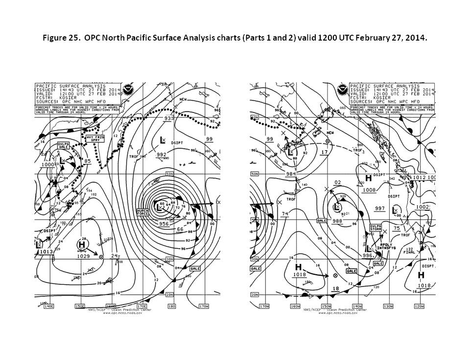
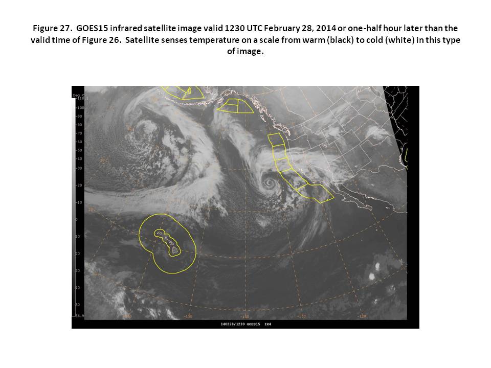
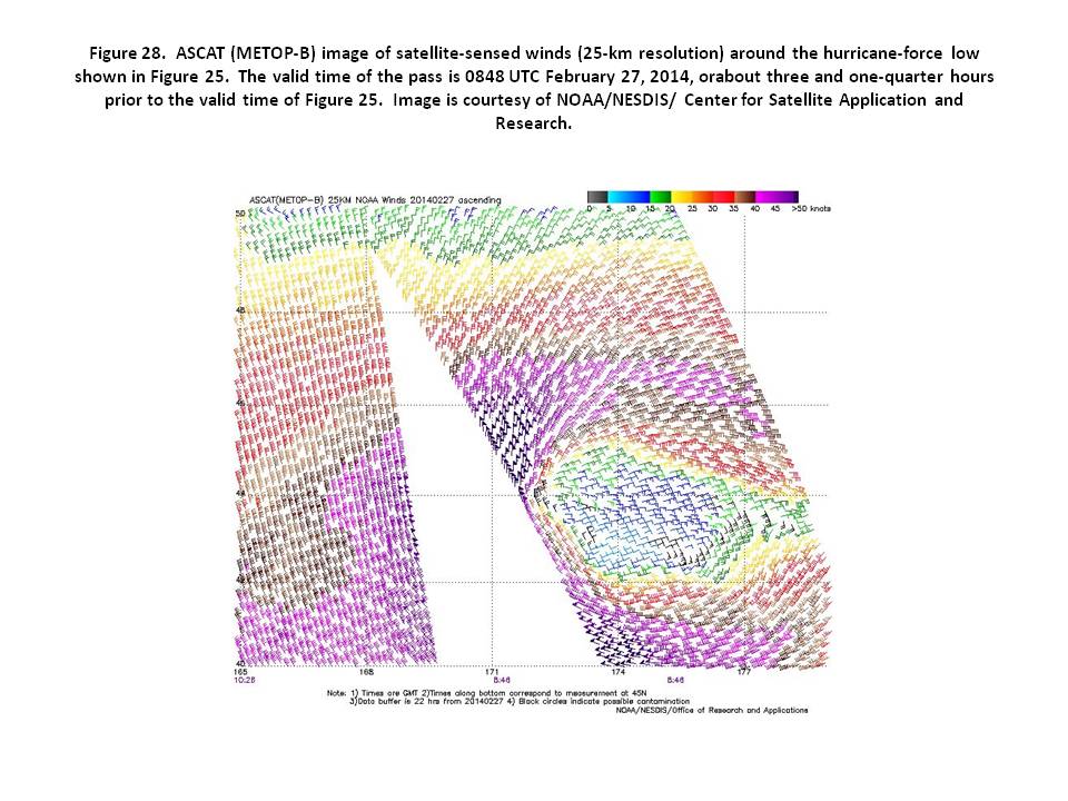
North Pacific Storm, February 26-March 1: Low pressure originating east of Japan near 37N 156E tracked east-northeast into the central waters 43N 175E at 1200 UTC on the 27th where it developed hurricane force winds and a lowest central pressure of 956 hPa (Figure 25). The infrared satellite image in Figure 27 shows a mature system with an expansive cloud pattern and frontal structure, reflecting some weakening of the system as in Figure 26. The ASCAT-B image in Figure 28 shows winds at least 50 to 55 kt in the southwest semicircle of the cyclone, with the data free gap between passes possibly missing the highest winds. The Kota Jati (VRWJ7) near 47N 175E reported northeast winds of 45 kt and 7.0 m seas (23 feet) at 2100 UTC on the 27th. The cyclone subsequently moved slowly east and weakened, with top winds diminishing to gale force early on March 1st.
Eastern North Pacific Storm, February 27-28: An intense low developed unusually far south off central California at the end of February with Figure 26 showing the cyclone at maximum intensity with a central pressure of 969 hPa. It originated as a secondary development on a front near 32N 137W at 1200 UTC on the 27th with its central pressure falling 27 hPa in the next 24 hour period. ASCAT-B imagery with limited coverage showed a small area of northwest winds of 50 kt to the west of the center. The Horizon Enterprise (KRGB) near 36N 137W reported northwest winds of 45 kt at 0000 UTC March 1st . Six hours later, the Overseas Anacortes (KCHV) near 31N 128W reported west winds of 45 kt and 8.8 m seas (29 feet). The cyclone drifted north and weakened over the next two days with its top winds diminishing to below gale force.
Back to top