SA Agulhas Deploys Drifting Weather Buoys
Ian Hunter, ManagerMaritime Services, South African Weather Service
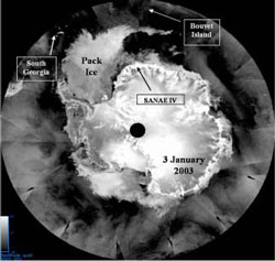 |
The satellite image shown on the right comes courtesy of the National Oceanic and Atmospheric Administration (NOAA) and National Aeronautics and Space Administration (NASA). It is a composite of all of the passes of the QuikSCAT satellite over the south pole over a 24 hour period, with the onboard SeaWinds Scatterometer providing information on both sea surface wind conditions and ice cover.
The South African polar relief vessel SA Agulhas, having offloaded cargo and personnel for the SANAE IV Antarctic base at Vesleskarvet, is now on a circular voyage which will take her around South Georgia and back to SANAE via the southernmost island of the South Sandwich Island chain, South Thule.
The sole purpose of this trip is to deploy several drifting weather buoys and to replace the automatic weather station on South Thule Island. The buoys form an extremely important component of the global network of meteorological data-gathering platforms. Their information is relayed via the ARGOS satellite data collection system to various receiving stations, and from there into numerical weather prediction models run by national meteorological services all around the world.
Without drifting weather buoys there would be no information over vast areas of the Southern Ocean, such as in the huge area between South Georgia, Bouvet Island and Gough Island, where much of the heavy swell affecting the southern African coastline is generated.
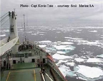 |
| On New Year's Day, the SA Agulhas sailed through the last of the pack ice arching eastwards south of Bouvet Island. |
On New Year's Day, the SA Agulhas sailed through the last of the pack ice arching eastwards south of Bouvet Island. She is now in open water heading WNW and deploying the weather buoys en route.
Three large icebergs are faintly visible on this satellite image, ranged around South Georgia. The original iceberg (A38) was calved from the Ronne Ice Shelf, 3000 kms to the south, in October 1998.
Page last modified: