Mean Circulation Highlights and
Climate Anomalies
May through August 2010
May - June 2010
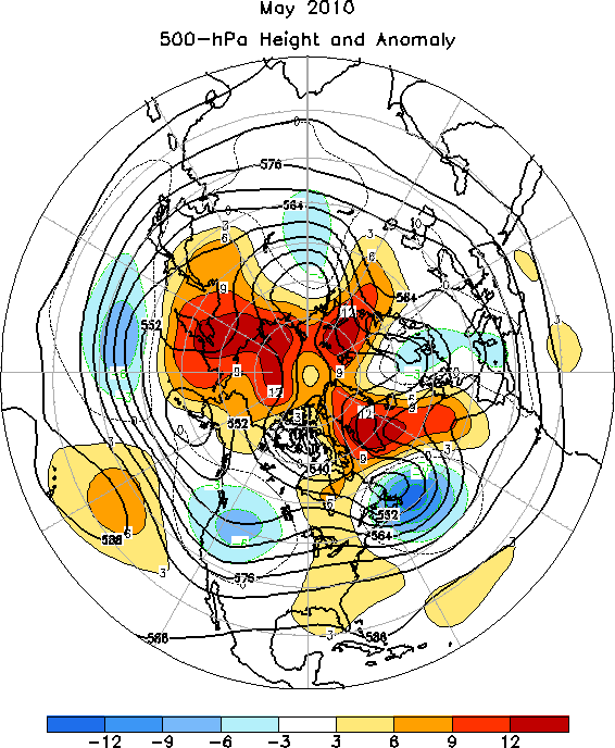
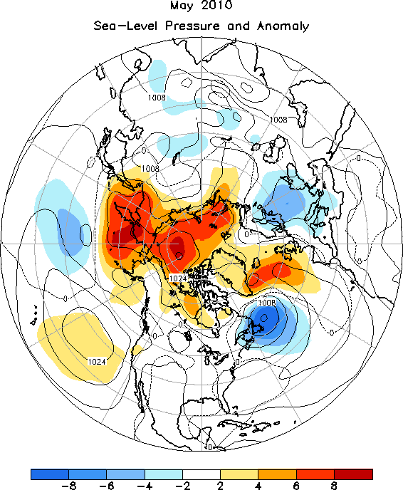
The 500 hPa circulation pattern over the Northern Hemisphere during May featured above average heights over the high latitudes, and generally below average heights over most of the mid-latitudes (Figure 1). This pattern reflected the negative phase of both the Arctic Oscillation (AO) and the North Atlantic Oscillation (NAO). The negative NAO signal has been very persistent since July 2009. The sea level pressure (SLP) pattern largely mirrors the 500 hPa pattern, and emphasizes the persistent area of lower than normal SLP near Newfoundland (Figure 2).
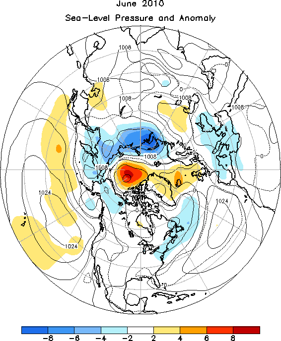
The mid-tropospheric circulation during June 2010 featured considerable zonal symmetry, with above average heights prevailing in the middle latitudes and the polar region, and below-average heights dominating much of the midhigh latitudes around 60N (Figure 3). The SLP map reflected a rather weak hemispheric pattern over temperate latitudes, with somewhat stronger anomalies over the polar region (Figure 4)
The Tropics
Positive sea surface temperature (SST) anomalies continued to decrease across most of the equatorial Pacific Ocean during May and June 2010. The latest monthly SST indices for the Nino 3.4 region were 0.0C (May) and -0.4C (June), respectively. The oceanic thermocline, measured by the depth of the 20C isotherm, was shallower than average across the central and eastern equatorial Pacific. Atmospheric convection was enhanced over Indonesia, and suppressed across the central equatorial Pacific. Equatorial low level easterly winds remained stronger than average over the western and central Pacific, while the upper-level westerly wind anomalies persisted across the central and eastern Pacific. Collectively, the atmospheric and oceanic anomalies signal the conclusion of this El Nino event (May), and developing La Nina conditions (June).
The 2010 Atlantic hurricane season began with Alex, which formed in the western Caribbean and attained tropical storm intensity before making its first landfall in Belize on June 26, with winds just under 60 kts. After emerging into the Bay of Campeche the following day, it began to restrengthen, making a second landfall several days later as a strong Category 2 hurricane south of Brownsville, TX. In the eastern Pacific, several tropical storms formed early in the season, followed by a category 5 hurricane named Celia. At peak intensity, this powerful hurricane had top winds of 140 kts, and an estimated barometric pressure of 921 hPa.
July-August 2010
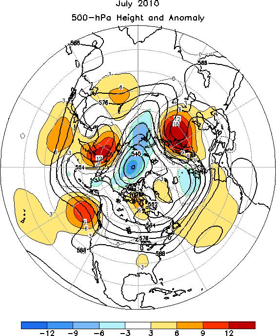
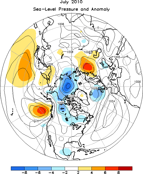
The 500 hPa circulation pattern during July 2010 featured above-average heights primarily at middle latitudes, and below-average heights in much of the polar basin (Figure 5). Heights were well above average (at least 90 m) over the Gulf of Alaska, Siberia, and northwestern Russia. The sea level pressure and anomaly map in figure 6 is a reasonable match (sign-wise) to the 500 hPa height anomaly map, though the 500 hPa ridging over Siberia was only weakly reflected at the surface.
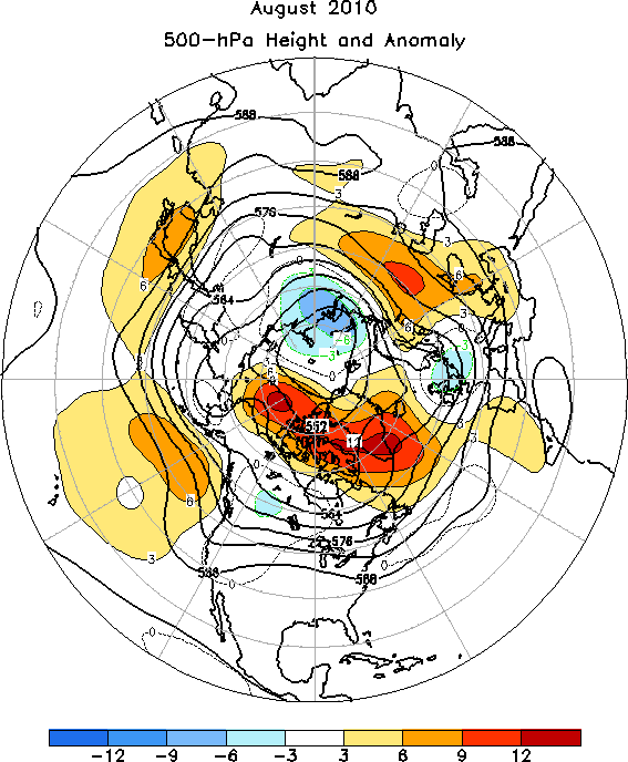
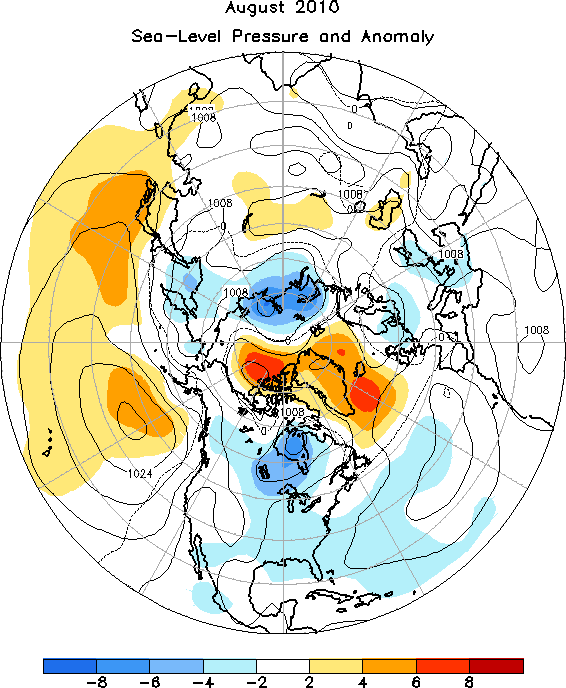
The month of August featured well above average 500 hPa heights across far northern portions of North America and adjacent portions of the Arctic Ocean, as well as over Greenland and Iceland (Figure 7). Above average heights also dominated much of the middle latitude Pacific, and from eastern Europe to central Russia. Relatively modest below average heights were noted over southwestern Canada, the British Isles, and north-central Russia. Interestingly, the SLP anomaly map (Figure 8) shows below average SLP from Hudson Bay to Lake Winnipeg, which is very weakly reflected in the 500 hPa height anomaly pattern.
The Tropics
Negative SST anomalies continued to strengthen across the equatorial Pacific Ocean during July and August 2010. The latest monthly SST indices for the Nino 3.4 region continued to fall, registering -0.9C in July and -1.2C in August. In fact, by August, all of the monthly Nino indices were at or below -1.0C. The oceanic thermocline (measured by the depth of the 20C isotherm) was shallower than average across the central and eastern equatorial Pacific, with sub-surface temperatures reaching 1C to 5C below average in the region. Deep cloudiness and thunderstorm activity near the equator was enhanced over Indonesia, and suppressed over the western and central equatorial Pacific. Equatorial low-level easterly trade winds and upper-level westerly winds remained stronger than average over the western and central Pacific. These atmospheric and oceanic anomalies reflect developing and strengthening La Nina conditions.
Several tropical storms formed over the Atlantic basin in July and early August, but it was not until the latter half of August that the second and third hurricanes of the season developed. Hurricanes Danielle and Earl both reached category 4 intensity. Danielle, the first of the Cape Verde-type storms, remained well east of any land areas, with top sustained winds of 120 kts. Hurricane Earl was several days behind Danielle, and crossed the Atlantic at lower latitudes than its predecessor. In the first few days of September, Earl would brush past Cape Hatteras, remain off the middle and northern Atlantic coasts, and eventually make landfall in Nova Scotia. Both Nova Scotia and Prince Edward Island experienced many uprooted trees and power outages from this hurricane.

- Climate Diagnostics Bulletin (http://www.cpc.ncep.noaa. gov/products/CDB/CDB_ Archive_html/bulletin_022010/ Extratropics/extratropics.shtml)
- Climate Diagnostics Bulletin (http://www.cpc.ncep.noaa. gov/products/CDB/CDB_ Archive_html/bulletin_022010/ Extratropics/extratropics.shtml)
Back to top