Mean Circulation Highlights and Climate
January-February 2010
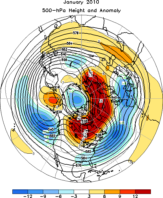
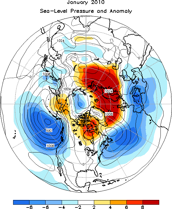
The 500 hPa circulation pattern over the Northern Hemisphere during January featured above average heights over northern Canada and the high latitudes of the North Atlantic and northern Europe, and below average heights over most of the mid-latitudes from the central Pacific eastward across the contiguous US and North Atlantic to southeastern Europe (Figure 1). The sea-level pressure (SLP) pattern largely mirrors the 500 hPa pattern, and emphasizes anomalously deep, as well as southward displaced, Aleutian and Icelandic Lows (Figure 2).
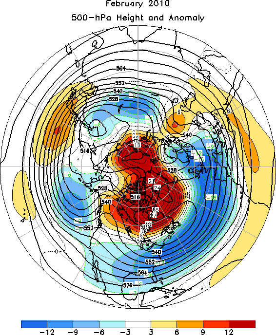
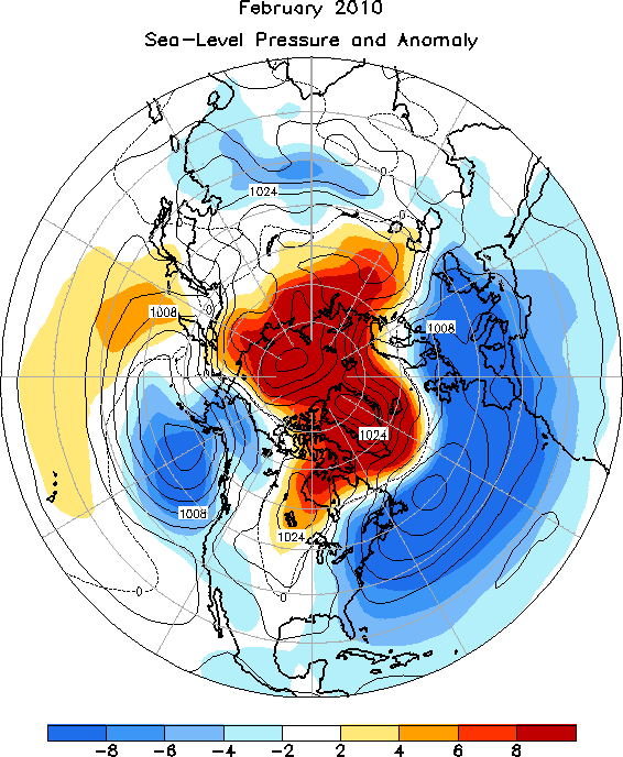
The mid-tropospheric circulation during February 2010 was similar to that of the previous month, though with larger negative height anomalies over the contiguous US, and more intense high latitude blocking centered near the southwestern tip of Greenland (Figure 3). The SLP map reflected a more intense and widespread version of the January SLP pattern (Figure 4), consistent with the second strongest (after 1978) negative phase of the North Atlantic Oscillation (NAO) recorded for February (-2.0, see Reference 1). The broader hemispheric pattern featured the combination of El Nino and a record negative phase of the Arctic Oscillation (-4.4, see Reference 2). These conditions contributed to several major snow storms along the eastern seaboard of the US.
The Tropics
A strong El Nino persisted during January 2010, as the sea surface temperatures (SSTs) remained well above average across the central and eastern equatorial Pacific Ocean. The latest monthly SST index for the Nino 3.4 region was +1.6C. The oceanic thermocline, measured by the depth of the 20C isotherm, remained deeper than average across the equatorial Pacific. In addition, convection was enhanced over the central equatorial Pacific, and low-level westerly and upper-level easterly wind anomalies were present over the equatorial Pacific. These oceanic and atmospheric indicators are consistent with warm episodes. However, unlike conventional El Nino events, tropical convection showed considerable week-to-week variability over Indonesia, where it is typically suppressed.
In February, El Nino persisted, as the SSTs remained well above average across the central and eastern equatorial Pacific Ocean. Although the latest monthly SST index for the Nino 3.4 region dropped to +1.2C, most of the oceanic and atmospheric indicators were consistent with those observed in January.
March-April 2010
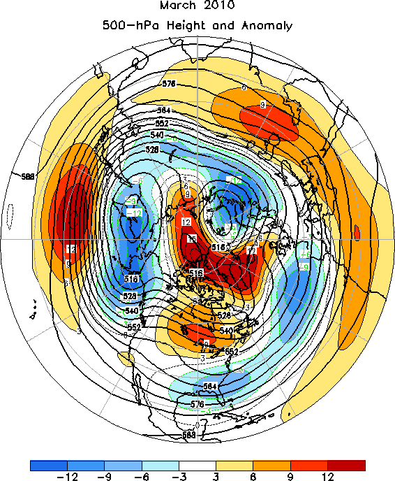
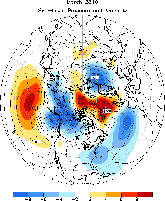
The 500 hPa circulation pattern during March 2010 featured above average heights at high latitudes and in the subtropics, and below average heights in the middle latitudes (Figure 5). The sea level pressure and anomaly map (Figure 6) is a reasonable match to the 500 hPa height anomaly map (in terms of sign), though there is an interesting feature to point out between Hudson Bay and the Great Lakes. The SLP anomaly map indicates near-average SLP in this general area, while the mid-tropospheric height anomaly map shows a moderately strong ridge aloft, with a maximum departure in excess of +90 m. This significantly weakened Hudson Bay low corresponded with warmer than average surface temperatures over the same region, and reflects a transitional period for the Northeast US, coming out of an unusually cold winter and heading into an anomalously warm April.
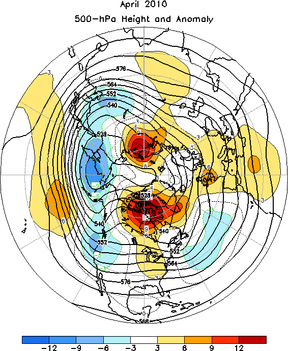
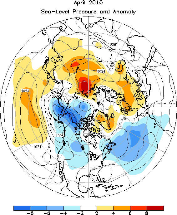
The month of April featured a weakening high latitude block centered over the Canadian archipelago, and another block of comparable magnitude and size on the opposite side of the Pole (Figure 7). An extensive band of below average 500 hPa heights stretched from northeast China to Alaska, and then southeast near and along the west coast of North America. The SLP pattern largely mirrored the 500 hPa height anomaly pattern over the Northern Hemisphere (Figure 8).
The Tropics
El Nino persisted during March 2010, as the sea surface temperatures (SSTs) remained well above average across the central and eastern equatorial Pacific Ocean. The latest monthly SST index for the Nino 3.4 region dropped slightly from the previous month, to +1.1C . Consistent with this warmth, the oceanic thermocline (measured by the depth of the 20C isotherm) remained deeper than average across the central and eastern equatorial Pacific. In addition, deep cloudiness and thunderstorm activity near the equator remained enhanced over the central and eastern Pacific, and suppressed across Indonesia and the western Pacific.
In April, El Nino weakened substantially, as the SST anomalies decreased across most of the equatorial Pacific Ocean. The latest monthly SST index for the Nino 3.4 region was +0.7C . The oceanic thermocline was shallower than average across the central equatorial Pacific, with sub-surface temperatures remaining below average in that region. Significant changes were also taking place in the atmospheric circulation as well. Equatorial low-level easterly winds remained stronger than average over the western Pacific, while the upper-level westerly wind anomalies persisted across the central Pacific. This wind pattern was associated with enhanced convection over Indonesia, and suppressed convection across the equatorial Pacific, south of the equator. Taken together, these oceanic and atmospheric anomalies reflect a weakening El Nino.
1. Climate Diagnostics Bulletin
2. Climate Diagnostics Bulletin