Wind and Wave Interaction During Hurricane Ike in 2008
Professor S. A. Hsu, Coastal Studies Institute, Louisiana State University, Email: sahsu@lsu.edu
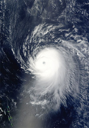
Hurrican Ike off the Lesser Antilles. (Image courtesy of NASA)
This brief report was motivated by Cobb et al. (2008, Figure 2) that Hurricane Ike in 2008 generated a maximum significant wave height of 48 ft based on the Geophysical Fluid Dynamics Laboratory (GFDL) version of the Wave Watch model. Also, in the northwest portion of Ikes eyewall, a stranded ship (Antolena) reported 42 ft seas. While both wave model and observation are important, there is a need to estimate Hsmax rapidly for operational use, for example, to safely perform a search and rescue mission.
In order to rapidly estimate the maximum significant wave height (Hsmax) generated by a tropical cyclone, Hsu (2005) has derived the following equation for operational applications,
Hsmax =0.2(1013Pmin) (1)
where Pmin is the minimum sea-level pressure.
Eq. (1) has been verified, among others, by Hsu (2005) for Hurricanes Lili in 2002 and by Hsu (2006) for Hurricane Katrina in 2005.
Before the application of Eq. (1) for Ike in 2008, some verification of basic wind and wave information are needed. According to the National Data Buoy Center (see www.ndbc. noaa.gov/hurricanes/2008/ike/), Hurricane Ike passed buoy 42001 (located in the central Gulf of Mexico) within 15 nm. Since wave parameters including significant wave height (Hs) and its dominant wave period (Tp) as well as the wind speed at 10 m (U10) were all measured during Ikes passage, we use those parameters to further verify the wind-wave interaction formula by Donelan et al. (1985) to derive Eq. (1).
In order to avoid the swell effect, the fully developed wave conditions given by (see, e.g., Hsu, 1988, p. 221)
Hs/gTp 2 = 0.0037 (2)
Applying Eq. (2) as a quality control, the period from 0750 Z September 11 to 1450 Z September 13 2008 at buoy 42001 was qualified for further analyses. Our results are provided in Figs. 1 and 2. If one accepts these relatively high R2 as shown in the figures, one can proceed to use Eq. (1) for the estimation of Hsmax. Now, according to Berg (2009) (www.nhc. noaa.gov/pddf/TCR-AL092008_Ike. pdf), Pmin of Ike while in the central Gulf was 944 mb. Substituting this value into Eq. (1), we get13.8 m or 45 ft for Hsmax. This value is in good agreement with that of 48 ft from GFDL Wave Watch model and that of 42 ft observed by the stranded ship Antolena.
It is concluded that Eq. (1) is further verified by Hurricane Ike in 2008 and thus recommended for use when rapid estimations are essential.
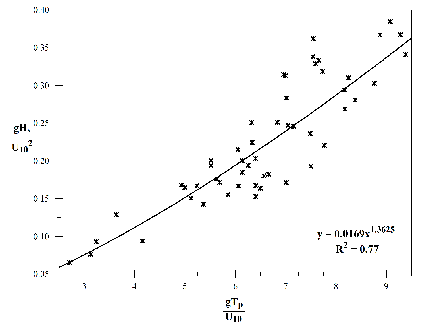
Figure 1. Wind and wave interaction at buoy 42001 during Hurricane Ike in 2008. (Click to enlarge)
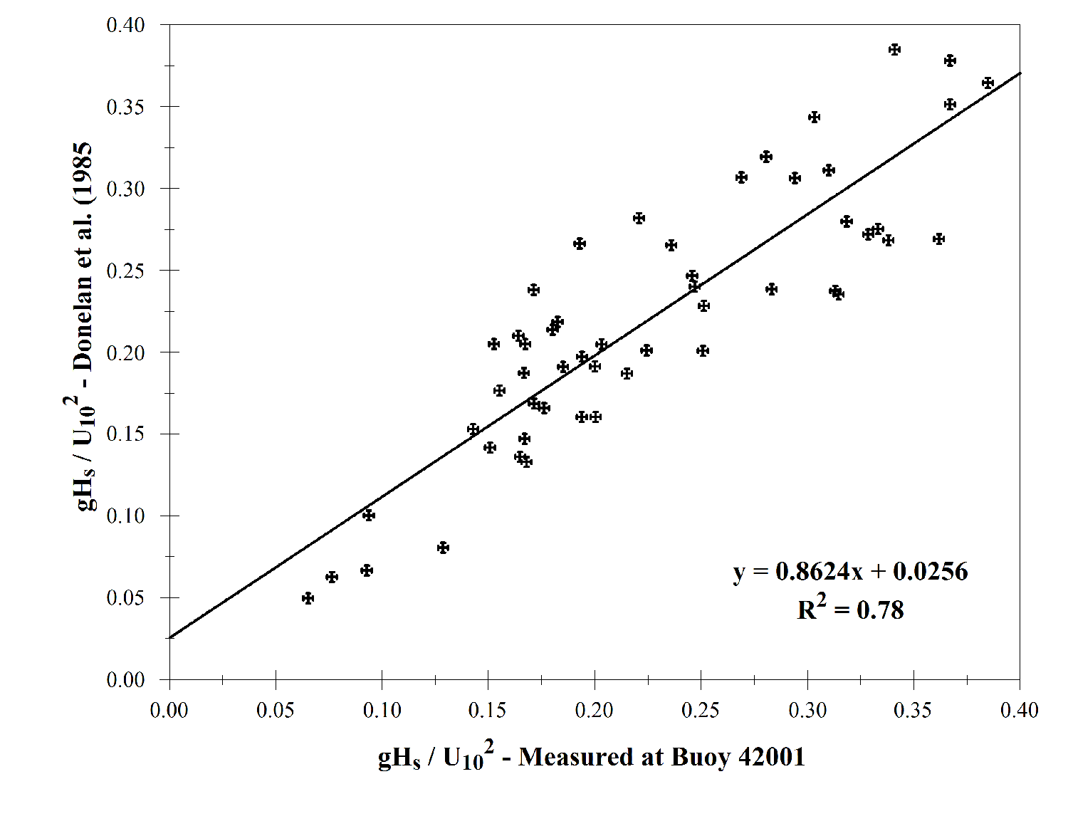
Figure 2. A verification of the wind-wave interaction formula used to derive Eq. (1) based on data from buoy 42001 during Hurricane Ike in 2008. (Click to enlarge)
References
Berg, R., 2009: Tropical Cyclone Report, Hurricane Ike (AL092008).
Cobb, H., J. Cangialosi, and J. S. Clark, 2008: Methodology for the determination of 12 ft sea radii for tropical cyclones. Mariners Weather Log, Vol. 52, No. 3, pp. 56-59.
Donelan, M. A., Hamilton, J., and Hui, W. H., 1985: Directional spectra of wind-generated waves. Philosophical Transactions Royal Society London, Ser. A, 315, 509-562.
Hsu, S. A., 1988: Coastal Meteorology. Academic Press, San Diego, CA.
Hsu, S. A., 2005: Air-Sea Interaction, in Water Encylopedia, Vol. 4, pp. 1-4, Wiley Interscience.
Hsu, S. A., 2006: Nowcasting the significant wave height during a hurricane. Mariners Weather Log, Vol. 50, No. 3, pp. 6-7.
Back to top