Historical Nautical Charts Collection: New York Harbor
Hell Gate and Its Approaches

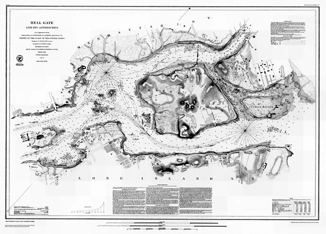
Figure 4. This 1851 nautical chart, depicts Hell Gate, a narrow channel on the East River, at the
confluence of the Harlem River, which connects Long Island Sound with New York Harbor. The chart shows Hell Gate in
1851, which is the year that the U.S. Army began blasting ledges and rocks within Hell Gate to ensure safe passage
through the channel.
(Click the image to enlarge.)
Like all nautical charts, this particular chart, Figure 4 shows water depths. The chart also includes a table with tidal observations for four locations along Hell Gate and a table with information on currents, including where they are strongest and weakest for eight identified stations. Ebb and flood currents are also depicted using arrows over "water" areas of the chart.
This nautical chart includes sailing instructions to enter Hell Gate from two directions. These directions identify obstacles to avoid, currents to watch out for, and even tips for when a mariner needs to drop anchor.
Historical Reference
In the 1700s and 1800s, strong currents and numerous rocks made Hell Gate a graveyard for ships. By the late 19th century, hundreds of ships had sunk in the channel.
In 1851, the year that this chart was published, the U.S. Army began blasting the submerged ledges and dangerous surface rocks within Hell Gate. This blasting continued for the next 70 years. At the time, the Hell Gate explosions were some of the young nation's earliest and most spectacular earthmoving projects. The largest Hell Gate explosion occurred in 1885 when, before an appreciative crowd of thousands, the nine-acre expanse of Flood Rock was blown away. Reports claimed the explosion could be felt as far away as Princeton, New Jersey. The New York Times devoted its entire cover page to this "triumph of human will over nature."
Works Consulted:
Kornblum, W. (2002). At Sea in the City: New York from the Water's Edge (Chapter 7) [Electronic version]. New York, New York: Algonquin Books of Chapel Hill. http://www.newyorkhistory.info/Hell-Gate/
