Mean Circulation Highlights and Climate Anomalies
September through December 2006
A. James Wagner, Senior Forecaster, Climate Operations Branch, Climate Prediction Center /NCEP/NWS/NOAA.
September-October 2006
The circulation pattern over the Northern Hemisphere during September and October was characterized by a polar vortex that was noticeably shifted to the Asian side of the Pole, and was centered near the coast of Siberia. Mid-tropospheric heights were well above normal over the Pole and in a continuous band extending from the Gulf of Alaska across northern Canada and Greenland and Scandinavia to eastern Europe. To the south of this area of above normal heights, a band of below normal heights extended from the central U.S. to the shores of western Europe. The 500 hPa heights were also above normal at middle latitudes over eastern Asia and the western Pacific.
The below normal heights over the central and eastern U.S. were associated with extensive areas of below normal temperature during both September and October, giving a cool early start to the fall season. This was the first instance of two consecutive months having extensive areas of below normal temperatures over a the Lower 48 States since summer 2004, and was in sharp contrast to the unusually mild summer-like conditions that persisted well into fall 2005. The resulting unusually strong westerlies over the central U.S. were accompanied by more vigorous frontal systems than normally observed at that time of year and contributed to outbreaks of severe weather more typical of Spring.
The Tropics
Sea surface temperatures (SSTs) over the equatorial Pacific continued to increase relative to normal and reached weak El Nino levels during September. Although there were probably no significant impacts on the climate of North America during this season, the relatively active eastern Pacific hurricane season and surprising lack of tropical activity in the Atlantic sector may have been an early effect of the developing El Nino. Several tropical systems that may have also been invigorated by above normal SSTs in the area affected the west coast of Mexico. Stronger than normal westerlies across the Atlantic at lower middle latitudes were also unfavorable for tropical storm development, and tended to steer most of the few storms that did develop away from land. One storm, Gordon, developed over the central Atlantic and was steered northeastward by the anomalous trough over the eastern Atlantic, producing hurricane force winds in the Azores, Spain, and the British Isles, although it had lost tropical characteristics before hitting the latter two areas. The area of above normal 500 hPa heights over the western Pacific contributed to steering several typhoons into eastern Asian countries. (Reference to article in this issue about the hurricane season in the Atlantic and Pacific)
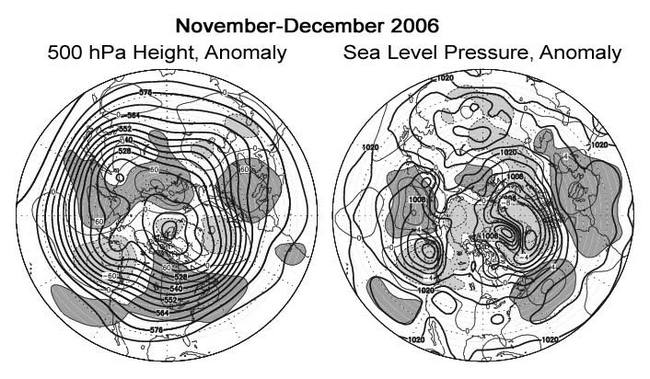
November - December 2006
During the late fall and early winter months, the 500 hPa circulation height anomalies almost exactly reversed sign from what had prevailed during the previous two months from the eastern Pacific to the central Atlantic. An unusually strong trough developed over the Gulf of Alaska, which steered intense, moisture-laden storms towards southern Alaska, British Columbia, and the Pacific Northwest. In the latter area, the rainy season started somewhat late, but rather dramatically with damaging floods, a rather unusual occurrence in a region accustomed to having rain for much of the year. Later in the season, a storm brought damaging winds that reached hurricane force to western Washington and Oregon.
The mean 500 hPa trough over eastern North America was weaker than normal, as evidenced by the large area of above normal mid-tropospheric heights over the northeastern U.S. and southeastern Canada. No significant Arctic air masses were able to develop over northern Canada, as can be inferred by the below normal mean seal level pressure (SLP) during these two months over northwestern Canada. The only significant wintry weather came early in the month when a strong trough in the upper flow pattern triggered a storm over the southern Plains that produced a swath of heavy snow and ice from Texas to the upper Mississippi Valley. Overall, well above normal temperatures prevailed over much of the northern and eastern U.S., especially during December which was the warmest on record at many locations in the Northeast. The lack of cold air left the Great Lakes open and extended the shipping season far later than usual.
Lower than normal 500 hPa heights and SLP at high latitudes and stronger than normal ridges over the western Atlantic and southern Europe combined to produce very fast westerlies across the middle latitudes of the Atlantic. A number of rapidly-moving vigorous storms struck northern and western Europe, including one in early December that brought a rare winter tornado to London. Unusually dry and mild weather continued across southern Europe and the Mediterranean area.
The Tropics
El Nino conditions in the equatorial Pacific continued to slowly strengthen and had reached moderate levels by December. By the end of the year, all of the equatorial Pacific from just west of the Date Line to the South American coast had above normal SSTs, and some of the atmospheric circulation indices were beginning to respond, although the actual values of SST had not reached high enough levels to support extensive convection on the Equator itself, either at the Date Line or near the coast of South America, where the SSTs were the most above normal. Other than the mild conditions over the north-central and northeastern states, and some episodes of heavy precipitation in the interior Southwest, which were caused more by circulation anomalies probably originating from extratropical causes, typical El Nino signatures of temperature and precipitation anomalies had not yet appeared outside of the tropics. Earlier in the fall a strong Madden-Julian Oscillation (MJO) created considerable warming of the near-surface waters as it moved eastward across the Pacific, but the next MJO wave, after starting strongly and triggering unusually heavy rain and floods in Indonesia, where it had been rather dry as is usually the case with El Nino, weakened as it moved out into the western Pacific.
Two typhoons did considerable damage and caused some fatalities in the Philippines during late November and December. A stronger than normal subtropical ridge over the western Pacific prevented recurvature and steered these storms westward.
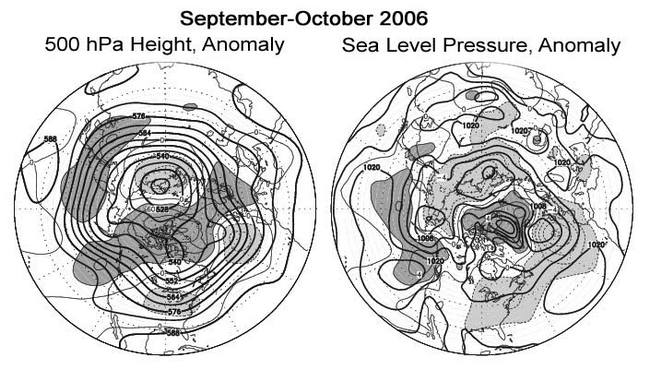
Figure legends and description of units:
The charts on the left show the seasonal mean 500 hPa height contours at 60 m intervals in heavy solid lines, with alternate contours labeled in decameters (dm). Positive height anomalies are contoured in light solid lines at 30 m intervals, and light dashed lines show negative height anomalies. Areas of mean height anomalies more than 30 m above normal have heavy shading, and areas of mean height anomalies more than 30 m below normal have light shading.
The charts ont the right show the seasonal mean sea level pressure (SLP) at 4 hPa intervals in heavy solid lines, labeled in hPa at selected intervals. Anomalies of SLP are contoured in light lines at 2 hPa intervals, with dark shading and solid lines in areas more than 2 hPa above normal, and light shading with dashed lines in areas greater than 2 hPa below normal.