Tropical Atlantic and Tropical East Pacific Areas May through August 2016


Jorge Aguirre-Echevarria and Dan Mundell
Tropical Analysis and Forecast Branch
National Hurricane Center, Miami, Florida
NOAA National Centers for Environmental Prediction


Atlantic Ocean including the Caribbean Sea and the Gulf of Mexico

There were seven (7) non-tropical cyclone gale events that occurred between 1 May and 31 August 2016 in the area of high seas forecast responsibility (7N to 31N, west of 35W including the Caribbean Sea and Gulf of Mexico) of the National Hurricane Center's (NHC) Tropical Analysis and Forecast Branch (TAFB). The Caribbean Sea basin had the most gale events for this time period, but considerably less than last year.

Table 1

Table 1. Non-tropical cyclone warnings issued for the subtropical and tropical Atlantic Ocean, including the Gulf of Mexico and Caribbean Sea between 1 May and 31 August 2016.

Pre-Earl Caribbean Gale Event:

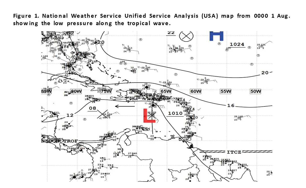
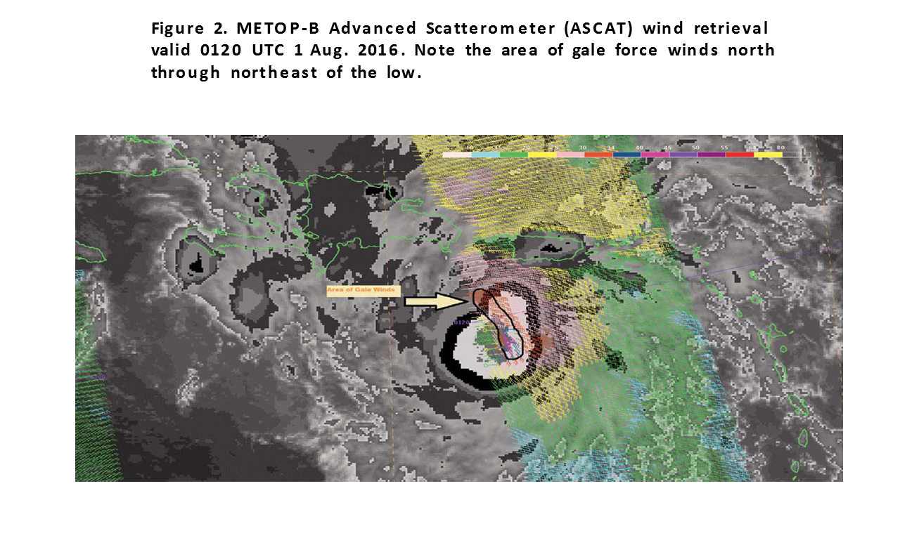
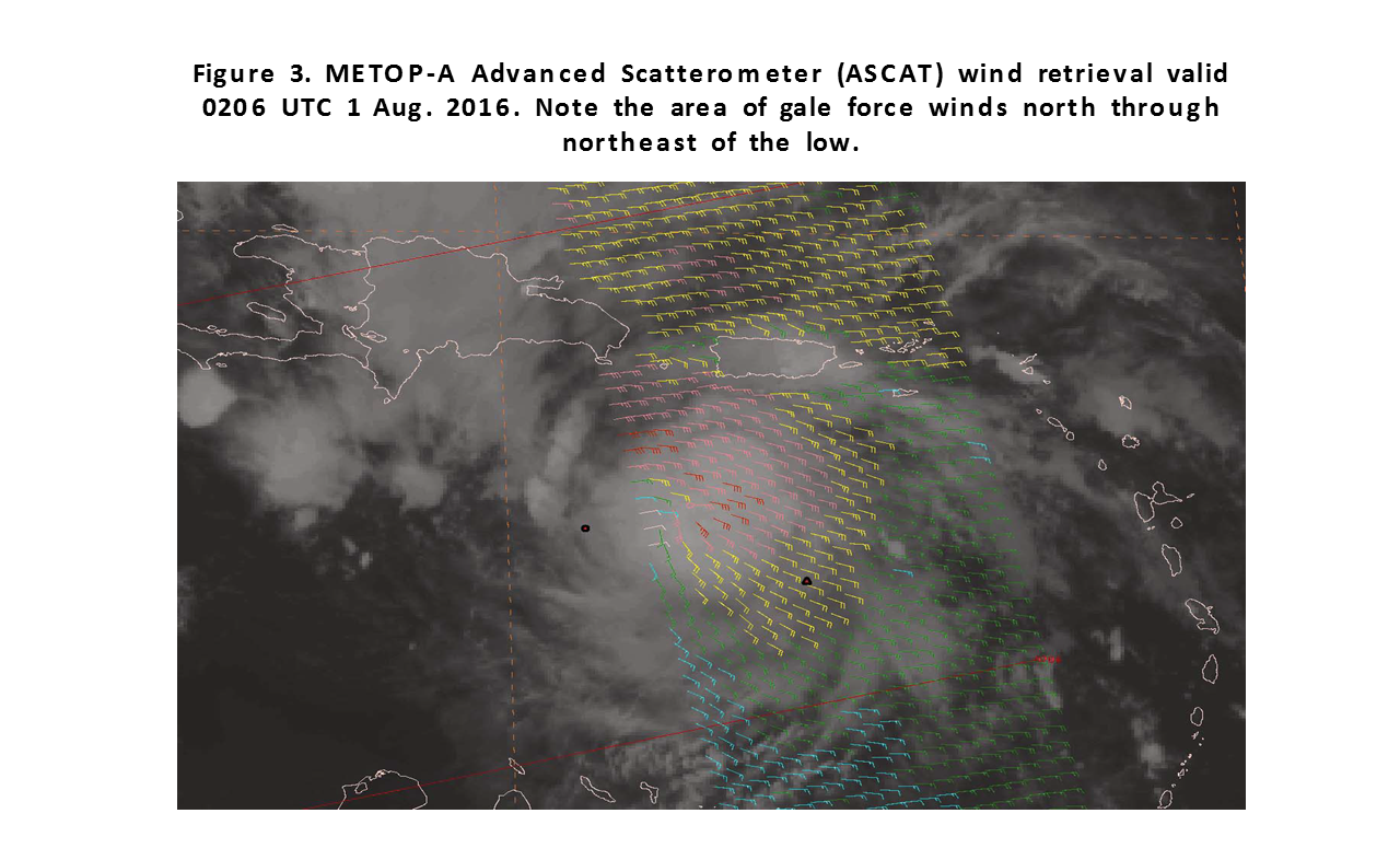
A strong tropical wave entered the eastern Caribbean Sea at about 1200 UTC on 31 July. The wave was moving rapidly westward along the southern periphery of the Atlantic subtropical high pressure. By 0000 UTC 1 August, low pressure of 1010 hPa had formed along the wave axis near 15N68W. (Figure 1) A tight isobaric spacing between the low pressure and the strong Atlantic high pressure induced east to southeast gale force winds of 25 to 35 kts from 15N to 18N between 66W and 69W with seas of 8 to 11 ft. (Figure 2 and Figure 3 ). The Ship BRASIL VOYAGER (C6ZJ8) just to the northeast of the low reported east winds of 35 kts. This report was very valuable to forecasters in confirmimg the presence of the gale force winds. By 1800 UTC on the same day the low had deepened some to 1007 hPa near 16.5N74W. The pressure gradient to its north remained tight per the surface analysis. (Figure 4)

An observation from ship KAROLINE N (A8PQ8) near the low center reported southeast winds of 35 kts at 18 UTC on August.1 near location 16N74W. During the night of 1 August, the low continued to deepen as was evident in the very cold cloud tops noted on satellite imagery from 0245 UTC 2 August with the METOP-B Advanced Scatterometer ASCAT pass showing quite an impressive coverage of strong gale force winds east of the low. (Figure 5). The low level circulation eventually became Tropical Storm Earl over the northwest Caribbean Sea at midday on 2 August.

Other Caribbean Gale Events

Other than the Pre-Earl gale event, there were three gale events in the favorable climatological area of strongest trade winds found over a portion of the southwest Caribbean Sea to the coasts of Colombia and northwestern Venezuela between 1 May and 31 August. The event that began at 00 UTC 17 June was rather short lived lasting for 12 hours. This particular event was confined from 11N to 13N between 74W and 77W, and included the Gulf of Venezuela. The pressure gradient between a narrow Atlantic high pressure ridge with axis roughly along 24N/25N, and low pressure across the Colombian basin initiated minimal gale force NE to E 30 to 35 kts winds with seas of 10 to 13 ft across that part of the SW Caribbean. (Figure 6) Note the tight gradient spacing just north of the coasts of Colombia and Venezuela between the 1016 hPa and 1012 hPa isobars.,(Figure 7). Interestingly, the ASCAT pass also showed similar gale force winds in the Gulf of Venezuela as noted in Figure 7.

This gulf is adjacent to the Caribbean Sea and serves heavy ship traffic. This gale event ended at 12 UTC 17 June when the narrow ridge began to retreat eastward in response to a broad area of troughing that began to settle in over the northwest portion of the southwest North Atlantic. The remaining gale events occurred under a similar synoptic scale pattern. The 18 hour duration event that began on 1 July was nicely captured by an ASCAT pass in its early stage, (Figure 8). Once these gale conditions diminished, the respite was not long before the next one started on 4 July. This gale event was even shorter in duration lasting only 9 hours.

Pre-Hermine Disturbance Gale Event

Low pressure with a pressure of 1009 hPamb was analyzed near 18N63W on the morning of 24 August. The low was along a strong tropical wave that had been moving westward at 10 to 15 kts across the tropical Atlantic, and had reached the Lesser Antilles that morning. The pressure gradient between the low pressure and high pressure to its northeast over the central Atlantic tightened enough to produce gale force east to southeast 30 to 35 kts winds within 90 nm in the northeast quadrant of the low along with seas of 10 to 12 ft, (Figure 9) ASCAT scatterometer data from that morning confirmed the gale force winds as were forecasted in the TAFB Atlantic high seas forecast issued at 1200 UTC 24 August. It also revealed that gale force winds had materialized to the south of the low, (Figure 10 and Figure 11 ). One interesting aspect of the scatterometer wind retrievals is the radial extent of the gale force winds to the northeast of the low surrounded by a large area of 20 to 30 kts winds. Also, noticeable in the imagery is a pocket of gale force southeast to south winds to the south of the low as verified by the absence of rain contaminated wind vectors there despite the presence of clouds and convection as seen in the satellite imagery. It was presumed that down bursts associated with the deep convective activity east and southeast of the low could have briefly produced wind gusts in excess of 35 kts as was observed by the Stepped Frequency Radiometer (SFMR) instrument on board an aircraft reconnaissance mission on the morning of 24 August. The aircraft observations also helped to assist in determining the radial extent of the gale force winds from the low. The low pressure moved across the southeastern Bahamas the following afternoon and evening, while at the same time weak low pressure was northeast of the Bahamas along a stationary frontal boundary. This synoptic set up helped weakened the tight gradient northeast of the aforementioned low pressure system allowing for the gale force winds to diminish to just below gale force the following day at 18 UTC on 25 August. The low continued to track westward reaching the Straits of Florida on 28 August where it was classified to be a tropical depression. It then intensified into tropical storm Hermine in the eastern Gulf of Mexico on 31 August.

Eastern North Pacific Ocean

One brief significant warning event (not associated with tropical cyclones) occurred during the May through August 2016 time period. Table 2 provides details on the gale wind event.

Table 2

Table 2. Non-tropical cyclone warnings issued for the subtropical and tropical eastern North Pacific between 1 May and 31 August 2016.

Gale warnings were issued prior to the first tropical cyclone advisory from the National Hurricane Center on the following tropical cyclones: Estelle, valid at 0000 UTC 15 July, fifteen hours prior to the first advisory; Lester, valid at 1200 UTC 24 August, nine hours previous to the first advisory; and Madeline, valid at 0600 UTC 26 August, fifteen hours prior to the first advisory. These gale warnings were issued for the benefit of mariners when a high probability of 34 kts or greater winds associated with a tropical low were expected within the next 48 hours, but the lack of a closed when a high probability of 34 kts or greater winds associated with a tropical low were expected within the next 48 hours, but the lack of a closed circulation or organized deep convection did not justify the issuance of tropical cyclone advisories at that time.

The only gale warning issued in the Eastern North Pacific from May through August not associated with a tropical cyclone was a late season high wind event in the Gulf of Tehuantepec during the first week of May. Late season Gulf of Tehuantepec wind events are typically initiated by strong northerly winds behind a cold front in the southwestern Gulf of Mexico, where the strong flow funnels cold air southward through the Chivela Pass across the Isthmus of Tehuantepec. A cold front moving across the western Gulf of Mexico in early May was expected to induce 30 kts northerly winds early in the morning of 5 May, and the Global Forecast System (GFS) model indicated peak winds the next morning would exceed 35 kts. Because the higher resolution GFS model has demonstrated better skill in identifying gale wind events during the past two winter seasons to marine forecasters than previous years, and there was enough run-to-run consistency in the model guidance to indicate there was a high likelihood of winds in excess of 33 kts, a gale warning was first issued 48 hours prior to the expected onset of gales at 0600 UTC 04 May. Subsequent forecasts indicated the gales were expected to commence between 0300 and 0600 UTC on May 6th, and persist about nine to 12 hours until 1800 UTC. Scatterometer data was unavailable over the Gulf of Tehuantepec between 0400 UTC 5 May and 1500 UTC 6 May, and there were no ship reports in the area during this time, so it is impossible to determine if a brief period of gale force winds actually occurred early in the morning of May 6th in the Gulf of Tehuantepec. The gale warning was discontinued at 1200 UTC 6 May, based on the most recent GFS model runs trending toward winds below gale force. In summary, it is inconclusive whether there were any significant warning events not associated with tropical cyclones in the Eastern North Pacific during the May through August 2016 time period, but if so, was likely very brief and confined to a small area near the coast of Mexico in the Gulf of Tehuantepec.


Back to top